

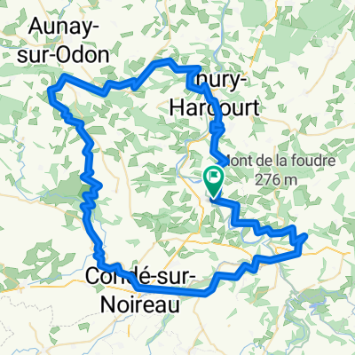
Parcours 100km Week-end Suisse Normande
A cycling route starting in Clécy, Normandy, France.
Overview
About this route
100km Course Weekend in Swiss Normandy
- -:--
- Duration
- 97.6 km
- Distance
- 829 m
- Ascent
- 810 m
- Descent
- ---
- Avg. speed
- ---
- Max. altitude

Route quality
Waytypes & surfaces along the route
Waytypes
Road
70.3 km
(72 %)
Quiet road
2.9 km
(3 %)
Surfaces
Paved
5.9 km
(6 %)
Unpaved
1 km
(1 %)
Asphalt
5.9 km
(6 %)
Gravel
1 km
(1 %)
Undefined
90.8 km
(93 %)
Continue with Bikemap
Use, edit, or download this cycling route
You would like to ride Parcours 100km Week-end Suisse Normande or customize it for your own trip? Here is what you can do with this Bikemap route:
Free features
- Save this route as favorite or in collections
- Copy & plan your own version of this route
- Split it into stages to create a multi-day tour
- Sync your route with Garmin or Wahoo
Premium features
Free trial for 3 days, or one-time payment. More about Bikemap Premium.
- Navigate this route on iOS & Android
- Export a GPX / KML file of this route
- Create your custom printout (try it for free)
- Download this route for offline navigation
Discover more Premium features.
Get Bikemap PremiumFrom our community
Other popular routes starting in Clécy
 Parcours 100km Week-end Suisse Normande
- Distance
- 97.6 km
- Ascent
- 829 m
- Descent
- 810 m
- Location
- Clécy, Normandy, France
 3éme étape Calva Camembert
- Distance
- 86.3 km
- Ascent
- 774 m
- Descent
- 774 m
- Location
- Clécy, Normandy, France
 Clecy to Caen
- Distance
- 77.1 km
- Ascent
- 83 m
- Descent
- 79 m
- Location
- Clécy, Normandy, France
 Place du Tripot, Clécy à Esplanade Jean-Marie Louvel, Caen
- Distance
- 39.8 km
- Ascent
- 56 m
- Descent
- 125 m
- Location
- Clécy, Normandy, France
 1ére étape Calva Camembert
- Distance
- 86.6 km
- Ascent
- 1,173 m
- Descent
- 1,172 m
- Location
- Clécy, Normandy, France
 Le bas de rouvrou - Hameau de neuville
- Distance
- 181.7 km
- Ascent
- 1,407 m
- Descent
- 1,469 m
- Location
- Clécy, Normandy, France
 Parcours 38km WE Suisse normande
- Distance
- 37.2 km
- Ascent
- 603 m
- Descent
- 600 m
- Location
- Clécy, Normandy, France
 Rouvrou -> Thury-Harcourt
- Distance
- 32.4 km
- Ascent
- 547 m
- Descent
- 580 m
- Location
- Clécy, Normandy, France
Open it in the app