
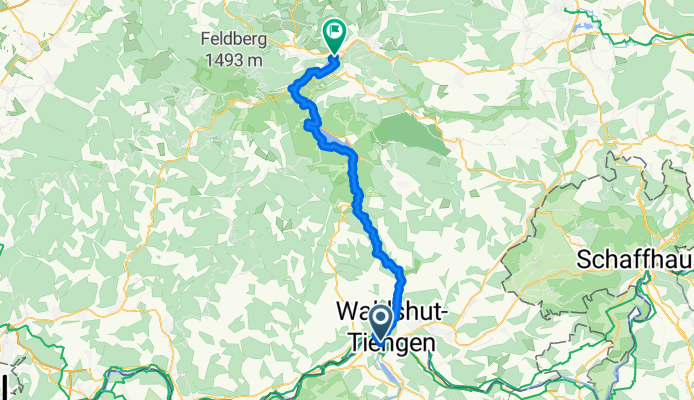
virée en foret noire/danube Constance etape 1 walshut lac de Titisee
A cycling route starting in Koblenz, Canton of Aargau, Switzerland.
Overview
About this route
I suggest doing the trilogy of Baden-Württemberg: Black Forest, source of the Danube, Danube gorges, Lake Constance, Rhine Falls. 2nd day in Donaueschingen starting from the source of the Danube at the Fürstenberg castle, following the Donauradweg.
- -:--
- Duration
- 51 km
- Distance
- 801 m
- Ascent
- 263 m
- Descent
- ---
- Avg. speed
- ---
- Max. altitude

Route quality
Waytypes & surfaces along the route
Waytypes
Track
19.4 km
(38 %)
Road
7.7 km
(15 %)
Surfaces
Paved
34.7 km
(68 %)
Unpaved
14.3 km
(28 %)
Asphalt
28.6 km
(56 %)
Gravel
11.7 km
(23 %)
Route highlights
Points of interest along the route
Point of interest after 47.4 km
camping
Point of interest after 51 km
prendre le train pour Donauweschingen
Continue with Bikemap
Use, edit, or download this cycling route
You would like to ride virée en foret noire/danube Constance etape 1 walshut lac de Titisee or customize it for your own trip? Here is what you can do with this Bikemap route:
Free features
- Save this route as favorite or in collections
- Copy & plan your own version of this route
- Sync your route with Garmin or Wahoo
Premium features
Free trial for 3 days, or one-time payment. More about Bikemap Premium.
- Navigate this route on iOS & Android
- Export a GPX / KML file of this route
- Create your custom printout (try it for free)
- Download this route for offline navigation
Discover more Premium features.
Get Bikemap PremiumFrom our community
Other popular routes starting in Koblenz
 Waldshut - Lörrach
- Distance
- 68.4 km
- Ascent
- 194 m
- Descent
- 166 m
- Location
- Koblenz, Canton of Aargau, Switzerland
 2_Waldshut bis Mulhouse
- Distance
- 108.2 km
- Ascent
- 368 m
- Descent
- 440 m
- Location
- Koblenz, Canton of Aargau, Switzerland
 Hausberg Maxi
- Distance
- 48.2 km
- Ascent
- 1,044 m
- Descent
- 1,041 m
- Location
- Koblenz, Canton of Aargau, Switzerland
 virée en foret noire/danube Constance etape 1 walshut lac de Titisee
- Distance
- 51 km
- Ascent
- 801 m
- Descent
- 263 m
- Location
- Koblenz, Canton of Aargau, Switzerland
 Koblenz nach Trasadingen
- Distance
- 22.1 km
- Ascent
- 103 m
- Descent
- 12 m
- Location
- Koblenz, Canton of Aargau, Switzerland
 Rhein 2019 2. Etappe
- Distance
- 59.9 km
- Ascent
- 199 m
- Descent
- 262 m
- Location
- Koblenz, Canton of Aargau, Switzerland
 Rhein - Wannenbwerg - Wutach
- Distance
- 42.9 km
- Ascent
- 606 m
- Descent
- 603 m
- Location
- Koblenz, Canton of Aargau, Switzerland
 teil4 mit herzenroute 580km
- Distance
- 576.4 km
- Ascent
- 9,803 m
- Descent
- 9,803 m
- Location
- Koblenz, Canton of Aargau, Switzerland
Open it in the app