

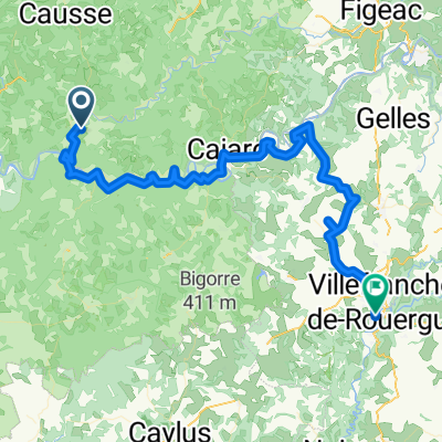
St Cirq a Montsalvy
A cycling route starting in Cajarc, Languedoc-Roussillon-Midi-Pyrénées, France.
Overview
About this route
ST Cirq a MOntsalvy following the Lot
- -:--
- Duration
- 104.4 km
- Distance
- 1,316 m
- Ascent
- 803 m
- Descent
- ---
- Avg. speed
- ---
- Avg. speed
Route quality
Waytypes & surfaces along the route
Waytypes
Busy road
54.5 km
(52 %)
Road
46.9 km
(45 %)
Surfaces
Paved
64 km
(61 %)
Asphalt
64 km
(61 %)
Undefined
40.4 km
(39 %)
Continue with Bikemap
Use, edit, or download this cycling route
You would like to ride St Cirq a Montsalvy or customize it for your own trip? Here is what you can do with this Bikemap route:
Free features
- Save this route as favorite or in collections
- Copy & plan your own version of this route
- Sync your route with Garmin or Wahoo
Premium features
Free trial for 3 days, or one-time payment. More about Bikemap Premium.
- Navigate this route on iOS & Android
- Export a GPX / KML file of this route
- Create your custom printout (try it for free)
- Download this route for offline navigation
Discover more Premium features.
Get Bikemap PremiumFrom our community
Other popular routes starting in Cajarc
 LePuy-Pamplona Etappe 06 Cajarc Cahors
- Distance
- 50.5 km
- Ascent
- 290 m
- Descent
- 312 m
- Location
- Cajarc, Languedoc-Roussillon-Midi-Pyrénées, France
 Vallée du Lot et du Celé
- Distance
- 103.6 km
- Ascent
- 472 m
- Descent
- 472 m
- Location
- Cajarc, Languedoc-Roussillon-Midi-Pyrénées, France
 Camboulan_Tour_02
- Distance
- 21.7 km
- Ascent
- 324 m
- Descent
- 322 m
- Location
- Cajarc, Languedoc-Roussillon-Midi-Pyrénées, France
 St Cirq a Montsalvy
- Distance
- 104.4 km
- Ascent
- 1,316 m
- Descent
- 803 m
- Location
- Cajarc, Languedoc-Roussillon-Midi-Pyrénées, France
 Od Dordogne do Provence 4.etapa
- Distance
- 77.2 km
- Ascent
- 849 m
- Descent
- 740 m
- Location
- Cajarc, Languedoc-Roussillon-Midi-Pyrénées, France
 Dordogne 20130712
- Distance
- 66.7 km
- Ascent
- 572 m
- Descent
- 486 m
- Location
- Cajarc, Languedoc-Roussillon-Midi-Pyrénées, France
 Limogne en Quercy - Durfort-Lacapelette - St. Martin
- Distance
- 95.3 km
- Ascent
- 1,122 m
- Descent
- 1,361 m
- Location
- Cajarc, Languedoc-Roussillon-Midi-Pyrénées, France
 Deutschland - Portugal (Berlin - Faro) FR 25 Cajarc - Cahors
- Distance
- 56.4 km
- Ascent
- 276 m
- Descent
- 322 m
- Location
- Cajarc, Languedoc-Roussillon-Midi-Pyrénées, France
Open it in the app