Mieussy 3 cols
A cycling route starting in Mieussy, Auvergne-Rh么ne-Alpes, France.
Overview
About this route
mieussy - samoens - morzine - col de l'encrenaz - praz de lys - mieussy
- -:--
- Duration
- 76.9 km
- Distance
- 2,008 m
- Ascent
- 2,028 m
- Descent
- ---
- Avg. speed
- ---
- Max. altitude
Route quality
Waytypes & surfaces along the route
Waytypes
Road
54.5 km
(71 %)
Busy road
17.9 km
(23 %)
Surfaces
Paved
67 km
(87 %)
Asphalt
67 km
(87 %)
Undefined
10 km
(13 %)
Continue with Bikemap
Use, edit, or download this cycling route
You would like to ride Mieussy 3 cols or customize it for your own trip? Here is what you can do with this Bikemap route:
Free features
- Save this route as favorite or in collections
- Copy & plan your own version of this route
- Sync your route with Garmin or Wahoo
Premium features
Free trial for 3 days, or one-time payment. More about Bikemap Premium.
- Navigate this route on iOS & Android
- Export a GPX / KML file of this route
- Create your custom printout (try it for free)
- Download this route for offline navigation
Discover more Premium features.
Get Bikemap PremiumFrom our community
Other popular routes starting in Mieussy
- EDT 2023 - officiel fin de parcours
- Distance
- 60.1 km
- Ascent
- 1,979 m
- Descent
- 1,916 m
- Location
- Mieussy, Auvergne-Rh么ne-Alpes, France
- Etapa 08 Tour de France 2010_zkr谩cen谩
- Distance
- 64 km
- Ascent
- 2,108 m
- Descent
- 918 m
- Location
- Mieussy, Auvergne-Rh么ne-Alpes, France
- Alpen 2008. Day 1 of 7.
- Distance
- 136.1 km
- Ascent
- 3,431 m
- Descent
- 3,126 m
- Location
- Mieussy, Auvergne-Rh么ne-Alpes, France
- Mieussy 3 cols
- Distance
- 76.9 km
- Ascent
- 2,008 m
- Descent
- 2,028 m
- Location
- Mieussy, Auvergne-Rh么ne-Alpes, France
- Alpes 2008 - Day 1 of 7 (alt.)
- Distance
- 122.1 km
- Ascent
- 3,081 m
- Descent
- 2,688 m
- Location
- Mieussy, Auvergne-Rh么ne-Alpes, France
- Mieussy
- Distance
- 88.1 km
- Ascent
- 1,660 m
- Descent
- 1,680 m
- Location
- Mieussy, Auvergne-Rh么ne-Alpes, France
- Cols Ramaz, Chavan and Cordon
- Distance
- 45.8 km
- Ascent
- 1,750 m
- Descent
- 1,750 m
- Location
- Mieussy, Auvergne-Rh么ne-Alpes, France
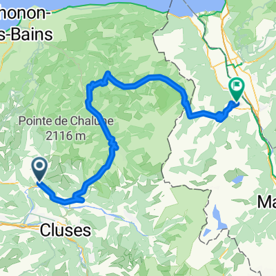
- Augustus-Col de la Ramaz- Col des Gets-Col de joux plane
- Distance
- 71 km
- Ascent
- 1,854 m
- Descent
- 1,859 m
- Location
- Mieussy, Auvergne-Rh么ne-Alpes, France
Open it in the app