

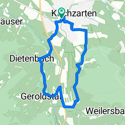
Freiburg - St. Peter. Glottertal - Freiburg
A cycling route starting in Kirchzarten, Baden-Wurttemberg, Germany.
Overview
About this route
10
- -:--
- Duration
- 37 km
- Distance
- 822 m
- Ascent
- 891 m
- Descent
- ---
- Avg. speed
- 758 m
- Max. altitude
Route quality
Waytypes & surfaces along the route
Waytypes
Road
7 km
19 %
Path
4.4 km
12 %
Surfaces
Paved
34.4 km
(93 %)
Unpaved
0.4 km
(1 %)
Asphalt
33.3 km
90 %
Paved (undefined)
1.1 km
3 %
Continue with Bikemap
Use, edit, or download this cycling route
You would like to ride Freiburg - St. Peter. Glottertal - Freiburg or customize it for your own trip? Here is what you can do with this Bikemap route:
Free features
- Save this route as favorite or in collections
- Copy & plan your own version of this route
- Sync your route with Garmin or Wahoo
Premium features
Free trial for 3 days, or one-time payment. More about Bikemap Premium.
- Navigate this route on iOS & Android
- Export a GPX / KML file of this route
- Create your custom printout (try it for free)
- Download this route for offline navigation
Discover more Premium features.
Get Bikemap PremiumFrom our community
Other popular routes starting in Kirchzarten
- Hirschenhofweg, Freiburg im Breisgau nach Hirschenhofweg, Freiburg im Breisgau0
- 43.3 km
- 953 m
- 953 m
- Kirchzarten, Baden-Wurttemberg, Germany
- Hirschenhofweg, Freiburg im Breisgau nach Hirschenhofweg, Freiburg im Breisgau0
- 44.2 km
- 996 m
- 996 m
- Kirchzarten, Baden-Wurttemberg, Germany
- Hirschenhofweg, Freiburg im Breisgau nach Hirschenhofweg, Freiburg im Breisgau0
- 36.1 km
- 156 m
- 154 m
- Kirchzarten, Baden-Wurttemberg, Germany


Open it in the app