

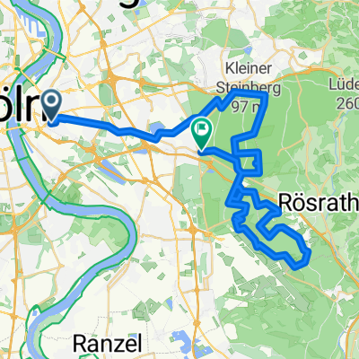
Rennrad/Triathlon - 50 km Flughafenrundfahrt KölnBonn
A cycling route starting in Humboldtkolonie, North Rhine-Westphalia, Germany.
Overview
About this route
-
Approx. 50 km tour - CologneBonn Airport circuit
-
Start/end point: Gießener Str. (Cologne-Gremberg)
-
especially suitable for road bike/triathlon
-
little car traffic (compared to tour via Frankfurter Str.)
Note: During the circuit, do not turn onto Altenrather Str. as it is quite a bumpy military road.
- -:--
- Duration
- 46.8 km
- Distance
- 144 m
- Ascent
- 142 m
- Descent
- ---
- Avg. speed
- ---
- Max. altitude
Route quality
Waytypes & surfaces along the route
Waytypes
Path
11.2 km
(24 %)
Road
10.8 km
(23 %)
Surfaces
Paved
37 km
(79 %)
Asphalt
36.5 km
(78 %)
Paved (undefined)
0.5 km
(1 %)
Undefined
9.8 km
(21 %)
Continue with Bikemap
Use, edit, or download this cycling route
You would like to ride Rennrad/Triathlon - 50 km Flughafenrundfahrt KölnBonn or customize it for your own trip? Here is what you can do with this Bikemap route:
Free features
- Save this route as favorite or in collections
- Copy & plan your own version of this route
- Sync your route with Garmin or Wahoo
Premium features
Free trial for 3 days, or one-time payment. More about Bikemap Premium.
- Navigate this route on iOS & Android
- Export a GPX / KML file of this route
- Create your custom printout (try it for free)
- Download this route for offline navigation
Discover more Premium features.
Get Bikemap PremiumFrom our community
Other popular routes starting in Humboldtkolonie
 Dillenburger Straße 5, Köln nach Hauptstraße 128, Köln
- Distance
- 7.3 km
- Ascent
- 41 m
- Descent
- 37 m
- Location
- Humboldtkolonie, North Rhine-Westphalia, Germany
 Importierte Route
- Distance
- 48.1 km
- Ascent
- 250 m
- Descent
- 241 m
- Location
- Humboldtkolonie, North Rhine-Westphalia, Germany
 Gießener Straße 52, Köln nach Hauptstraße 122, Köln
- Distance
- 7.1 km
- Ascent
- 40 m
- Descent
- 37 m
- Location
- Humboldtkolonie, North Rhine-Westphalia, Germany
 Deutz-Kalker-Straße 142A, Köln nach Brüsseler Straße 11, Köln
- Distance
- 4.8 km
- Ascent
- 32 m
- Descent
- 29 m
- Location
- Humboldtkolonie, North Rhine-Westphalia, Germany
 1.Tag Köln- Düsseldorf
- Distance
- 54 km
- Ascent
- 71 m
- Descent
- 72 m
- Location
- Humboldtkolonie, North Rhine-Westphalia, Germany
 Trimbornstraße 21, Köln nach Perlenpfuhl 25, Köln
- Distance
- 4 km
- Ascent
- 40 m
- Descent
- 33 m
- Location
- Humboldtkolonie, North Rhine-Westphalia, Germany
 JS Laufroute
- Distance
- 14.2 km
- Ascent
- 85 m
- Descent
- 86 m
- Location
- Humboldtkolonie, North Rhine-Westphalia, Germany
 Dillenburger Straße 7, Köln nach Nippes, Köln
- Distance
- 12 km
- Ascent
- 39 m
- Descent
- 37 m
- Location
- Humboldtkolonie, North Rhine-Westphalia, Germany
Open it in the app