

Acampada Embiciada
A cycling route starting in Quito, Pichincha, Ecuador.
Overview
About this route
Prepare your bike, pack your tent and other camping gear, we will head to a place where nature will welcome you with a very beautiful landscape, to enjoy sport fishing, boat rides, and put your survival instincts to the test, of course in the company of friends and the good spirit that has always characterized us.
- -:--
- Duration
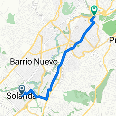
- 46.2 km
- Distance
- 1,208 m
- Ascent
- 664 m
- Descent
- ---
- Avg. speed
- ---
- Max. altitude

Continue with Bikemap
Use, edit, or download this cycling route
You would like to ride Acampada Embiciada or customize it for your own trip? Here is what you can do with this Bikemap route:
Free features
- Save this route as favorite or in collections
- Copy & plan your own version of this route
- Sync your route with Garmin or Wahoo
Premium features
Free trial for 3 days, or one-time payment. More about Bikemap Premium.
- Navigate this route on iOS & Android
- Export a GPX / KML file of this route
- Create your custom printout (try it for free)
- Download this route for offline navigation
Discover more Premium features.
Get Bikemap PremiumFrom our community
Other popular routes starting in Quito
 CHIRIVUELTA
- Distance
- 66.3 km
- Ascent
- 1,088 m
- Descent
- 3,253 m
- Location
- Quito, Pichincha, Ecuador
 De QF4H+XVR, Quito a QF4H+XVR, Quito
- Distance
- 31.3 km
- Ascent
- 491 m
- Descent
- 505 m
- Location
- Quito, Pichincha, Ecuador
 Parque Ecológico de solanda - Luluncoto (Bicinema)
- Distance
- 6.6 km
- Ascent
- 69 m
- Descent
- 125 m
- Location
- Quito, Pichincha, Ecuador
 Ruta senderismo
- Distance
- 30 km
- Ascent
- 714 m
- Descent
- 711 m
- Location
- Quito, Pichincha, Ecuador
 UNGUI - RIO BLANCO
- Distance
- 29 km
- Ascent
- 344 m
- Descent
- 1,525 m
- Location
- Quito, Pichincha, Ecuador
 CHIRIVUELTA
- Distance
- 66.2 km
- Ascent
- 1,272 m
- Descent
- 3,396 m
- Location
- Quito, Pichincha, Ecuador
 El Cinto-Torouco-Cruz Loma
- Distance
- 19.4 km
- Ascent
- 1,032 m
- Descent
- 349 m
- Location
- Quito, Pichincha, Ecuador
 Quito - Chiriboga - Santo Domingo
- Distance
- 106.8 km
- Ascent
- 1,547 m
- Descent
- 3,949 m
- Location
- Quito, Pichincha, Ecuador
Open it in the app