

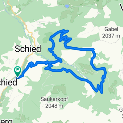
Alpendorf Runde Böndelsee 40km
A cycling route starting in Schwarzach im Pongau, Salzburg, Austria.
Overview
About this route
Alpendorf - Böndelsee The tour first leads down to the Tauernradweg along the Salzach up to Schwarzach. Here, turn right into Putzengrabenstraße. This takes us over Goldeggweng to Böndelsee. We continue partly steeply downhill to Lend. After crossing the railway line and the Salzach bridge, we continue right to Oberlend up to the main school. Here, sharply turn left into the so-called Lärchenwald and continue to the Gasteiner intersection. Here, sharply turn left into Klammweg. This leads us to the balancing reservoir for the district of Oberuntersberg. From now on, it’s downhill to Schwarzach, along the Tauernradweg by the Salzach until shortly before Sankt Johann. Now there's just a small ascent back to the starting point at Alpendorf.
- -:--
- Duration
- 39.2 km
- Distance
- 761 m
- Ascent
- 766 m
- Descent
- ---
- Avg. speed
- ---
- Max. altitude

Continue with Bikemap
Use, edit, or download this cycling route
You would like to ride Alpendorf Runde Böndelsee 40km or customize it for your own trip? Here is what you can do with this Bikemap route:
Free features
- Save this route as favorite or in collections
- Copy & plan your own version of this route
- Sync your route with Garmin or Wahoo
Premium features
Free trial for 3 days, or one-time payment. More about Bikemap Premium.
- Navigate this route on iOS & Android
- Export a GPX / KML file of this route
- Create your custom printout (try it for free)
- Download this route for offline navigation
Discover more Premium features.
Get Bikemap PremiumFrom our community
Other popular routes starting in Schwarzach im Pongau
 S12_15
- Distance
- 8.1 km
- Ascent
- 388 m
- Descent
- 210 m
- Location
- Schwarzach im Pongau, Salzburg, Austria
 Richterhöhe 12, Schwarzach im Pongau nach Oberuntersberg 6, Sankt Veit im Pongau
- Distance
- 13.8 km
- Ascent
- 556 m
- Descent
- 530 m
- Location
- Schwarzach im Pongau, Salzburg, Austria
 Großarl: Karseggalm
- Distance
- 19.5 km
- Ascent
- 891 m
- Descent
- 891 m
- Location
- Schwarzach im Pongau, Salzburg, Austria
 19.05.2018
- Distance
- 32.8 km
- Ascent
- 768 m
- Descent
- 669 m
- Location
- Schwarzach im Pongau, Salzburg, Austria
 Großarl: Unterwandalm - Karseggalm
- Distance
- 19.5 km
- Ascent
- 825 m
- Descent
- 824 m
- Location
- Schwarzach im Pongau, Salzburg, Austria
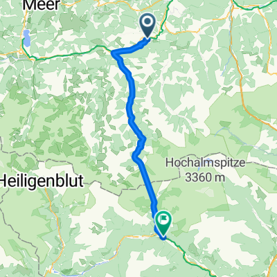 Schwarzach im Pongau - Obervellach
- Distance
- 59.2 km
- Ascent
- 864 m
- Descent
- 772 m
- Location
- Schwarzach im Pongau, Salzburg, Austria
 Alpendorf Runde Böndelsee 40km
- Distance
- 39.2 km
- Ascent
- 761 m
- Descent
- 766 m
- Location
- Schwarzach im Pongau, Salzburg, Austria
 Sankt Johann Alpendorf - Hüttschlag 40km Teil 1
- Distance
- 23.5 km
- Ascent
- 640 m
- Descent
- 361 m
- Location
- Schwarzach im Pongau, Salzburg, Austria
Open it in the app