

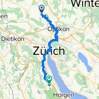
Flughafenrunde1
A cycling route starting in Oberglatt / Bahnhofquartier, Canton of Zurich, Switzerland.
Overview
About this route
02.06.13 10:45 (cloned from route 2159030)
- -:--
- Duration
- 21.4 km
- Distance
- 122 m
- Ascent
- 123 m
- Descent
- ---
- Avg. speed
- ---
- Max. altitude
Route quality
Waytypes & surfaces along the route
Waytypes
Quiet road
7.7 km
(36 %)
Path
7.7 km
(36 %)
Surfaces
Paved
19.5 km
(91 %)
Unpaved
0.6 km
(3 %)
Asphalt
19.3 km
(90 %)
Gravel
0.6 km
(3 %)
Continue with Bikemap
Use, edit, or download this cycling route
You would like to ride Flughafenrunde1 or customize it for your own trip? Here is what you can do with this Bikemap route:
Free features
- Save this route as favorite or in collections
- Copy & plan your own version of this route
- Sync your route with Garmin or Wahoo
Premium features
Free trial for 3 days, or one-time payment. More about Bikemap Premium.
- Navigate this route on iOS & Android
- Export a GPX / KML file of this route
- Create your custom printout (try it for free)
- Download this route for offline navigation
Discover more Premium features.
Get Bikemap PremiumFrom our community
Other popular routes starting in Oberglatt / Bahnhofquartier
 Flughafenrunde1
- Distance
- 21.4 km
- Ascent
- 122 m
- Descent
- 123 m
- Location
- Oberglatt / Bahnhofquartier, Canton of Zurich, Switzerland
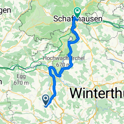
 Glattburg - Schaffhausen
- Distance
- 52.3 km
- Ascent
- 534 m
- Descent
- 576 m
- Location
- Oberglatt / Bahnhofquartier, Canton of Zurich, Switzerland
 Bahnhofstrasse 47, Oberglatt ZH nach Alte Dorfstrasse 1–5B, Langnau am Albis
- Distance
- 30.6 km
- Ascent
- 316 m
- Descent
- 263 m
- Location
- Oberglatt / Bahnhofquartier, Canton of Zurich, Switzerland
 Rhein 2019 1.Etappe
- Distance
- 43.6 km
- Ascent
- 113 m
- Descent
- 197 m
- Location
- Oberglatt / Bahnhofquartier, Canton of Zurich, Switzerland
 Entspannende Route in Oberhasli
- Distance
- 14.1 km
- Ascent
- 174 m
- Descent
- 185 m
- Location
- Oberglatt / Bahnhofquartier, Canton of Zurich, Switzerland
 Zurich Flughafen to Schaffhausen
- Distance
- 44 km
- Ascent
- 311 m
- Descent
- 338 m
- Location
- Oberglatt / Bahnhofquartier, Canton of Zurich, Switzerland
 47.461, 8.499 nach 40.907, 29.320
- Distance
- 1,855.8 km
- Ascent
- 10,992 m
- Descent
- 11,914 m
- Location
- Oberglatt / Bahnhofquartier, Canton of Zurich, Switzerland
 Bad Zurzach
- Distance
- 65 km
- Ascent
- 582 m
- Descent
- 582 m
- Location
- Oberglatt / Bahnhofquartier, Canton of Zurich, Switzerland
Open it in the app