
Sonntag 11.08.2013
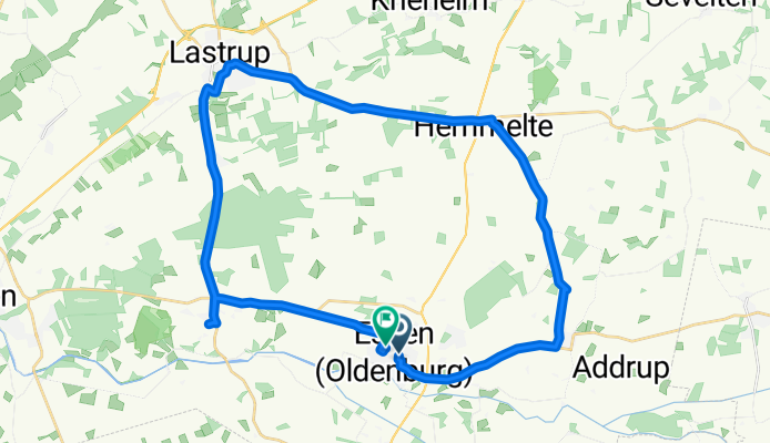
A cycling route starting in Essen, Lower Saxony, Germany.
Overview
About this route
Rundfahrt von Essen oldb. nach Bevern, Hemmelter, Lastrup, Neuenbrunnen zurük nach Essen.
- -:--
- Duration
- 33.8 km
- Distance
- 71 m
- Ascent
- 72 m
- Descent
- ---
- Avg. speed
- ---
- Max. altitude
Route quality
Waytypes & surfaces along the route
Waytypes
Path
11.3 km
(33 %)
Quiet road
10.3 km
(30 %)
Surfaces
Paved
30 km
(89 %)
Unpaved
0 km
(<1 %)
Asphalt
28.6 km
(85 %)
Paving stones
1.4 km
(4 %)
Continue with Bikemap
Use, edit, or download this cycling route
You would like to ride Sonntag 11.08.2013 or customize it for your own trip? Here is what you can do with this Bikemap route:
Free features
- Save this route as favorite or in collections
- Copy & plan your own version of this route
- Sync your route with Garmin or Wahoo
Premium features
Free trial for 3 days, or one-time payment. More about Bikemap Premium.
- Navigate this route on iOS & Android
- Export a GPX / KML file of this route
- Create your custom printout (try it for free)
- Download this route for offline navigation
Discover more Premium features.
Get Bikemap PremiumFrom our community
Other popular routes starting in Essen
 Annegrets erste Route
- Distance
- 19.7 km
- Ascent
- 37 m
- Descent
- 37 m
- Location
- Essen, Lower Saxony, Germany
 Essen (OL) -> saterland
- Distance
- 53.9 km
- Ascent
- 334 m
- Descent
- 392 m
- Location
- Essen, Lower Saxony, Germany
 00013
00013- Distance
- 32 km
- Ascent
- 155 m
- Descent
- 161 m
- Location
- Essen, Lower Saxony, Germany
 Essen Cloppenburg
- Distance
- 18.1 km
- Ascent
- 43 m
- Descent
- 31 m
- Location
- Essen, Lower Saxony, Germany
 Flachetappe, fast nur Landstraßen und Radwege
- Distance
- 43.9 km
- Ascent
- 23 m
- Descent
- 21 m
- Location
- Essen, Lower Saxony, Germany
 Calhorn- Essen
- Distance
- 18 km
- Ascent
- 58 m
- Descent
- 71 m
- Location
- Essen, Lower Saxony, Germany
 8 Essen über Bakum nach Lutten
- Distance
- 32.7 km
- Ascent
- 31 m
- Descent
- 23 m
- Location
- Essen, Lower Saxony, Germany
 Sommertour 2019_2
- Distance
- 13.1 km
- Ascent
- 20 m
- Descent
- 22 m
- Location
- Essen, Lower Saxony, Germany
Open it in the app