
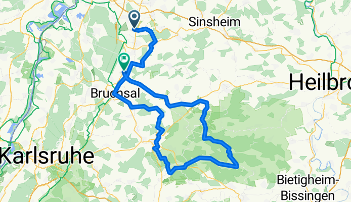
Malsch-Maulbronn-Ubstadt-Weiher
A cycling route starting in Malsch, Baden-Wurttemberg, Germany.
Overview
About this route
Immer wieder ordentliche Steigungen, aber auch schöne Abfahrten. Landschaftlich sehr schön.
- -:--
- Duration
- 108.2 km
- Distance
- 684 m
- Ascent
- 688 m
- Descent
- ---
- Avg. speed
- ---
- Max. altitude

Route quality
Waytypes & surfaces along the route
Waytypes
Road
32.5 km
(30 %)
Quiet road
9.7 km
(9 %)
Surfaces
Paved
96.3 km
(89 %)
Unpaved
4.3 km
(4 %)
Asphalt
94.1 km
(87 %)
Paved (undefined)
2.2 km
(2 %)
Continue with Bikemap
Use, edit, or download this cycling route
You would like to ride Malsch-Maulbronn-Ubstadt-Weiher or customize it for your own trip? Here is what you can do with this Bikemap route:
Free features
- Save this route as favorite or in collections
- Copy & plan your own version of this route
- Split it into stages to create a multi-day tour
- Sync your route with Garmin or Wahoo
Premium features
Free trial for 3 days, or one-time payment. More about Bikemap Premium.
- Navigate this route on iOS & Android
- Export a GPX / KML file of this route
- Create your custom printout (try it for free)
- Download this route for offline navigation
Discover more Premium features.
Get Bikemap PremiumFrom our community
Other popular routes starting in Malsch
 Rettichheim - Nussloch
- Distance
- 15 km
- Ascent
- 130 m
- Descent
- 109 m
- Location
- Malsch, Baden-Wurttemberg, Germany
 Tiefenbach 32
- Distance
- 32.1 km
- Ascent
- 415 m
- Descent
- 409 m
- Location
- Malsch, Baden-Wurttemberg, Germany
 Kraichgau 35
- Distance
- 34.2 km
- Ascent
- 309 m
- Descent
- 295 m
- Location
- Malsch, Baden-Wurttemberg, Germany
 Malsch-Maulbronn-Ubstadt-Weiher
- Distance
- 108.2 km
- Ascent
- 684 m
- Descent
- 688 m
- Location
- Malsch, Baden-Wurttemberg, Germany
 St Leon-Rot (SAP) - Karlsruhe
- Distance
- 40.8 km
- Ascent
- 55 m
- Descent
- 59 m
- Location
- Malsch, Baden-Wurttemberg, Germany
 MTB BHF Rot - Forst - ROT BHF
- Distance
- 30.9 km
- Ascent
- 51 m
- Descent
- 51 m
- Location
- Malsch, Baden-Wurttemberg, Germany
 Flache Runde in Richtung Rhein
- Distance
- 55 km
- Ascent
- 167 m
- Descent
- 169 m
- Location
- Malsch, Baden-Wurttemberg, Germany
 Rundfahrt um Mühlhausen
- Distance
- 22.4 km
- Ascent
- 258 m
- Descent
- 218 m
- Location
- Malsch, Baden-Wurttemberg, Germany
Open it in the app