
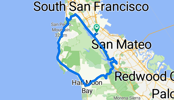
Millbrae to Half Moon Bay Loop
A cycling route starting in Millbrae, California, United States.
Overview
About this route
Millbrae to Half Moon Bay Loop
- -:--
- Duration
- 63.8 km
- Distance
- 909 m
- Ascent
- 902 m
- Descent
- ---
- Avg. speed
- ---
- Max. altitude
Continue with Bikemap
Use, edit, or download this cycling route
You would like to ride Millbrae to Half Moon Bay Loop or customize it for your own trip? Here is what you can do with this Bikemap route:
Free features
- Save this route as favorite or in collections
- Copy & plan your own version of this route
- Sync your route with Garmin or Wahoo
Premium features
Free trial for 3 days, or one-time payment. More about Bikemap Premium.
- Navigate this route on iOS & Android
- Export a GPX / KML file of this route
- Create your custom printout (try it for free)
- Download this route for offline navigation
Discover more Premium features.
Get Bikemap PremiumFrom our community
Other popular routes starting in Millbrae
 Millbrae to Half Moon Bay Loop
- Distance
- 63.8 km
- Ascent
- 909 m
- Descent
- 902 m
- Location
- Millbrae, California, United States
 Sawyer Camp Recreation Trail
- Distance
- 9.7 km
- Ascent
- 122 m
- Descent
- 208 m
- Location
- Millbrae, California, United States
 Big Basin trip
- Distance
- 79.8 km
- Ascent
- 1,277 m
- Descent
- 952 m
- Location
- Millbrae, California, United States
 00a SFO
- Distance
- 4.7 km
- Ascent
- 10 m
- Descent
- 4 m
- Location
- Millbrae, California, United States
 CA trip
- Distance
- 2,121.3 km
- Ascent
- 4,698 m
- Descent
- 4,672 m
- Location
- Millbrae, California, United States
 USA tour
- Distance
- 6,251.6 km
- Ascent
- 5,038 m
- Descent
- 5,018 m
- Location
- Millbrae, California, United States
 390 El Camino Real, Millbrae to 68–98 Blanken Ave, San Francisco
- Distance
- 14.5 km
- Ascent
- 0 m
- Descent
- 6 m
- Location
- Millbrae, California, United States
 BW-LS-GB
- Distance
- 37.4 km
- Ascent
- 276 m
- Descent
- 217 m
- Location
- Millbrae, California, United States
Open it in the app