- 25.3 km
- 241 m
- 226 m
- Ciudad Juárez, Chihuahua, Mexico
Carrera MTB Chupacabras 2013 100kms Juarez, Mexico Salida en la X
A cycling route starting in Ciudad Juárez, Chihuahua, Mexico.Consists of riding 100 kilometers on a mountain bike and it is the first mountain biking race taking place on the Mexican side of the border with the United States along the Río Bravo and the Sierra de Juárez. It features the participation of local cyclists, from all over Mexico and many other countries to be part of the largest extreme sports challenge in Mexico. It is the only race that takes place in a desert area under extreme terrain and climate conditions and is held annually on the second Saturday of October in Cd. Juárez, Chih, Mexico.
- -:--
- Duration
- 99.5 km
- Distance
- 675 m
- Ascent
- 675 m
- Descent
- ---
- Avg. speed
- ---
- Max. altitude
Point of interest after 5.8 km
Puente A. J. Bermudez
Point of interest after 9.6 km
Planta Tratadora
Point of interest after 11.6 km
Road Runners Trail
Point of interest after 15.8 km
Kalambres Trail
Point of interest after 35.9 km
El Coliseo
Point of interest after 36.7 km
Paso Tarántulas
Point of interest after 37.8 km
Don Rayo Trail
Point of interest after 40.4 km
Liebres Trail
Point of interest after 44.4 km
Oreja de Coyote
Point of interest after 46.7 km
El Nido
Point of interest after 47.7 km
La Domadora
Point of interest after 49.5 km
Kamikaze Trail
Point of interest after 53 km
Cascabeles Trail
Point of interest after 54.5 km
Transformers Trail
Point of interest after 55.5 km
Kamaleones Trail
Point of interest after 60.9 km
Puerto Castrellon
Point of interest after 62.9 km
Dragones Trail
Point of interest after 66.2 km
Laredos Trail
Point of interest after 67.4 km
Chambelanes Trail
Point of interest after 68.9 km
Magnificos Trail
Point of interest after 73.5 km
La Mal Querida
Point of interest after 75 km
La Alemana
Point of interest after 75.1 km
Los Potreros
Point of interest after 75.7 km
Ruleta #1
Point of interest after 76 km
La Ruleta #2
Point of interest after 76.7 km
La Bufadora
Point of interest after 78.7 km
Don Rayo
Point of interest after 79.4 km
Raptors Trail
Point of interest after 82.4 km
Cristo de Curiel
Point of interest after 87.8 km
Subida de Paty
Point of interest after 91.3 km
Parque Tortugas
Point of interest after 92.7 km
El Talud
Point of interest after 93.7 km
Puente Santa Fe
Point of interest after 97.6 km
Puente Libre
- Save this route as favorite or in collections
- Copy & plan your own version of this route
- Split it into stages to create a multi-day tour
- Sync your route with Garmin or Wahoo
Free trial for 3 days, or one-time payment. More about Bikemap Premium.
- Navigate this route on iOS & Android
- Export a GPX / KML file of this route
- Create your custom printout (try it for free)
- Download this route for offline navigation
Discover more Premium features.
Get Bikemap Premium- 
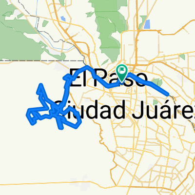
De Eje Vial Juan Gabriel a Benito Juárez
- Carrera MTB Chupacabras 2015 100kms Juarez, Mexico.
- 98.3 km
- 657 m
- 655 m
- Ciudad Juárez, Chihuahua, Mexico
- emdep
- 7.8 km
- 19 m
- 62 m
- Ciudad Juárez, Chihuahua, Mexico
- De Benito Juárez a Benito Juárez
- 2.1 km
- 57 m
- 45 m
- Ciudad Juárez, Chihuahua, Mexico
- Ruta Infantil D "All Start here". MTB Race Octubre 23, 2011
- 19.3 km
- 230 m
- 230 m
- Ciudad Juárez, Chihuahua, Mexico
- All Star Here Categorias Principiantes,Femenil, Ruffles 2012
- 28.1 km
- 374 m
- 374 m
- Ciudad Juárez, Chihuahua, Mexico
- Ruta Infantil A y B "All Start here". MTB Race Octubre 23, 2011
- 1.7 km
- 45 m
- 45 m
- Ciudad Juárez, Chihuahua, Mexico
- De Aguirre Laredo a Aguirre Laredo
- 33.4 km
- 50 m
- 37 m
- Ciudad Juárez, Chihuahua, Mexico
Open it in the app


