training13
A cycling route starting in Ormalingen, Basel-Landschaft, Switzerland.
Overview
About this route
abwechslungsreiche Trainingsrunde
- -:--
- Duration
- 35.9 km
- Distance
- 863 m
- Ascent
- 863 m
- Descent
- ---
- Avg. speed
- ---
- Avg. speed
Route quality
Waytypes & surfaces along the route
Waytypes
Track
21.2 km
(59 %)
Quiet road
6.7 km
(19 %)
Surfaces
Paved
13.9 km
(39 %)
Unpaved
18.8 km
(52 %)
Gravel
13.9 km
(39 %)
Asphalt
11 km
(31 %)
Continue with Bikemap
Use, edit, or download this cycling route
You would like to ride training13 or customize it for your own trip? Here is what you can do with this Bikemap route:
Free features
- Save this route as favorite or in collections
- Copy & plan your own version of this route
- Sync your route with Garmin or Wahoo
Premium features
Free trial for 3 days, or one-time payment. More about Bikemap Premium.
- Navigate this route on iOS & Android
- Export a GPX / KML file of this route
- Create your custom printout (try it for free)
- Download this route for offline navigation
Discover more Premium features.
Get Bikemap PremiumFrom our community
Other popular routes starting in Ormalingen
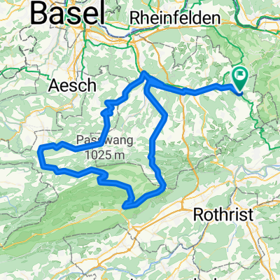
- Passwang - Unt. Hauenstein
- Distance
- 113.1 km
- Ascent
- 1,210 m
- Descent
- 1,204 m
- Location
- Ormalingen, Basel-Landschaft, Switzerland
- Tecknau Luzern
- Distance
- 85.8 km
- Ascent
- 934 m
- Descent
- 939 m
- Location
- Ormalingen, Basel-Landschaft, Switzerland
- Rothenfluh - Diegten - Langenbruck - Mümliswil - Passwang - Büsserach - Fehren - Nunningen - Reigoldswil - Oberdorf - Hölstein - Diegten - Sissach - Rothenfluh
- Distance
- 102 km
- Ascent
- 1,490 m
- Descent
- 1,490 m
- Location
- Ormalingen, Basel-Landschaft, Switzerland
- Mandach - Ampferenhöhe - Bözen
- Distance
- 75 km
- Ascent
- 1,006 m
- Descent
- 999 m
- Location
- Ormalingen, Basel-Landschaft, Switzerland
- Oberer und Unterer Hauenstein mit Rothrist und Kölliken
- Distance
- 114.3 km
- Ascent
- 966 m
- Descent
- 955 m
- Location
- Ormalingen, Basel-Landschaft, Switzerland
- schafmatt
- Distance
- 18.3 km
- Ascent
- 458 m
- Descent
- 468 m
- Location
- Ormalingen, Basel-Landschaft, Switzerland
- Tecknau Luzern Waldvariante
- Distance
- 87.7 km
- Ascent
- 1,451 m
- Descent
- 1,459 m
- Location
- Ormalingen, Basel-Landschaft, Switzerland
- Albtal - St. Blasien - Wehratal
- Distance
- 121.2 km
- Ascent
- 1,196 m
- Descent
- 1,190 m
- Location
- Ormalingen, Basel-Landschaft, Switzerland
Open it in the app