
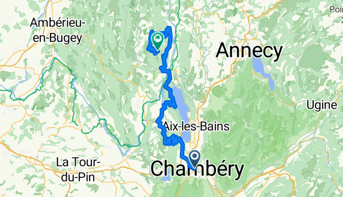
Chambery - le Grand Colombier
A cycling route starting in Cognin, Auvergne-Rhône-Alpes, France.
Overview
About this route
Tough stage for the tour de france
- -:--
- Duration
- 128.4 km
- Distance
- 4,237 m
- Ascent
- 2,999 m
- Descent
- ---
- Avg. speed
- ---
- Max. altitude
Route quality
Waytypes & surfaces along the route
Waytypes
Road
86.1 km
(67 %)
Quiet road
3.9 km
(3 %)
Surfaces
Paved
78.3 km
(61 %)
Asphalt
74.5 km
(58 %)
Paved (undefined)
3.9 km
(3 %)
Undefined
50.1 km
(39 %)
Continue with Bikemap
Use, edit, or download this cycling route
You would like to ride Chambery - le Grand Colombier or customize it for your own trip? Here is what you can do with this Bikemap route:
Free features
- Save this route as favorite or in collections
- Copy & plan your own version of this route
- Split it into stages to create a multi-day tour
- Sync your route with Garmin or Wahoo
Premium features
Free trial for 3 days, or one-time payment. More about Bikemap Premium.
- Navigate this route on iOS & Android
- Export a GPX / KML file of this route
- Create your custom printout (try it for free)
- Download this route for offline navigation
Discover more Premium features.
Get Bikemap PremiumFrom our community
Other popular routes starting in Cognin
 Road to perdiyio
- Distance
- 82.9 km
- Ascent
- 1,909 m
- Descent
- 2,044 m
- Location
- Cognin, Auvergne-Rhône-Alpes, France
 jarrier bidob
- Distance
- 11.8 km
- Ascent
- 76 m
- Descent
- 47 m
- Location
- Cognin, Auvergne-Rhône-Alpes, France
 Granier - col des Egaux
- Distance
- 53.4 km
- Ascent
- 1,326 m
- Descent
- 1,325 m
- Location
- Cognin, Auvergne-Rhône-Alpes, France
 4 COLS CHARTREUSE 24/03/2015
- Distance
- 57.8 km
- Ascent
- 1,479 m
- Descent
- 1,477 m
- Location
- Cognin, Auvergne-Rhône-Alpes, France
 granier via st baldoph et pas de la fosse
- Distance
- 17.9 km
- Ascent
- 923 m
- Descent
- 57 m
- Location
- Cognin, Auvergne-Rhône-Alpes, France
 RANDO SAINT SULPICE
- Distance
- 14.9 km
- Ascent
- 532 m
- Descent
- 535 m
- Location
- Cognin, Auvergne-Rhône-Alpes, France
 Col de l'Epine - col du Chat
- Distance
- 55.8 km
- Ascent
- 1,209 m
- Descent
- 1,209 m
- Location
- Cognin, Auvergne-Rhône-Alpes, France
 bauges VTT
- Distance
- 591.1 km
- Ascent
- 7,630 m
- Descent
- 7,559 m
- Location
- Cognin, Auvergne-Rhône-Alpes, France
Open it in the app