

na hnusny pivo do zizkova
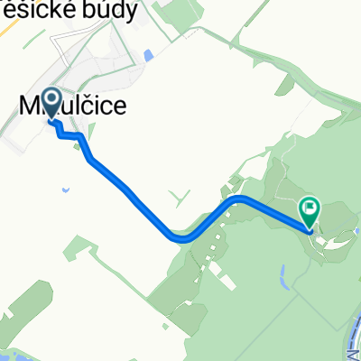
A cycling route starting in Mikulčice, South Moravian, Czechia.
Overview
About this route
prusanky zizkov podvorov kalaby luzice mikulcice
- -:--
- Duration
- 33.3 km
- Distance
- 173 m
- Ascent
- 175 m
- Descent
- ---
- Avg. speed
- ---
- Max. altitude
Route quality
Waytypes & surfaces along the route
Waytypes
Quiet road
15.4 km
(46 %)
Track
7.5 km
(23 %)
Surfaces
Paved
11.6 km
(35 %)
Unpaved
4.3 km
(13 %)
Asphalt
7.9 km
(24 %)
Unpaved (undefined)
3.8 km
(11 %)
Continue with Bikemap
Use, edit, or download this cycling route
You would like to ride na hnusny pivo do zizkova or customize it for your own trip? Here is what you can do with this Bikemap route:
Free features
- Save this route as favorite or in collections
- Copy & plan your own version of this route
- Sync your route with Garmin or Wahoo
Premium features
Free trial for 3 days, or one-time payment. More about Bikemap Premium.
- Navigate this route on iOS & Android
- Export a GPX / KML file of this route
- Create your custom printout (try it for free)
- Download this route for offline navigation
Discover more Premium features.
Get Bikemap PremiumFrom our community
Other popular routes starting in Mikulčice
 bukal mlyn z mikulek
- Distance
- 62.6 km
- Ascent
- 310 m
- Descent
- 307 m
- Location
- Mikulčice, South Moravian, Czechia
 MORAVA-6.den-20.7.13
- Distance
- 65.2 km
- Ascent
- 244 m
- Descent
- 232 m
- Location
- Mikulčice, South Moravian, Czechia
 mikulcice-lednice
- Distance
- 67.6 km
- Ascent
- 148 m
- Descent
- 147 m
- Location
- Mikulčice, South Moravian, Czechia
 Silnice Bez Názvu do Chvalovice
- Distance
- 222.7 km
- Ascent
- 1,780 m
- Descent
- 1,759 m
- Location
- Mikulčice, South Moravian, Czechia
 Silnice 05526, Moravská Nová Ves až Dolní, Moravská Nová Ves
- Distance
- 3.1 km
- Ascent
- 32 m
- Descent
- 0 m
- Location
- Mikulčice, South Moravian, Czechia
 Mikulčice, Mikulčice do Mikulčice, Mikulčice
- Distance
- 3.9 km
- Ascent
- 9 m
- Descent
- 17 m
- Location
- Mikulčice, South Moravian, Czechia
 Mikulčice 738, Mikulčice až U Elektrárny 1–3, Hodonín
- Distance
- 8.2 km
- Ascent
- 197 m
- Descent
- 196 m
- Location
- Mikulčice, South Moravian, Czechia
 na hnusny pivo do zizkova
- Distance
- 33.3 km
- Ascent
- 173 m
- Descent
- 175 m
- Location
- Mikulčice, South Moravian, Czechia
Open it in the app