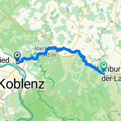
Bendorf-Selters-Vallendar
A cycling route starting in Bendorf, Rhineland-Palatinate, Germany.
Overview
About this route
Sayntal hoch - über Kausen nach Selters - dann Wirges - Höhr-Grenzhausen-Vallendar
- -:--
- Duration
- 58.6 km
- Distance
- 578 m
- Ascent
- 528 m
- Descent
- ---
- Avg. speed
- ---
- Avg. speed
Route quality
Waytypes & surfaces along the route
Waytypes
Busy road
46 km
(78 %)
Road
6.7 km
(11 %)
Surfaces
Paved
35.2 km
(60 %)
Unpaved
0.5 km
(<1 %)
Asphalt
33.4 km
(57 %)
Paved (undefined)
1.1 km
(2 %)
Continue with Bikemap
Use, edit, or download this cycling route
You would like to ride Bendorf-Selters-Vallendar or customize it for your own trip? Here is what you can do with this Bikemap route:
Free features
- Save this route as favorite or in collections
- Copy & plan your own version of this route
- Sync your route with Garmin or Wahoo
Premium features
Free trial for 3 days, or one-time payment. More about Bikemap Premium.
- Navigate this route on iOS & Android
- Export a GPX / KML file of this route
- Create your custom printout (try it for free)
- Download this route for offline navigation
Discover more Premium features.
Get Bikemap PremiumFrom our community
Other popular routes starting in Bendorf
- Rheinsteig Etappe 8 Sayn - Koblenz
- Distance
- 20 km
- Ascent
- 554 m
- Descent
- 478 m
- Location
- Bendorf, Rhineland-Palatinate, Germany
- Ritterweg Anhausen Melsbach
- Distance
- 36.2 km
- Ascent
- 661 m
- Descent
- 669 m
- Location
- Bendorf, Rhineland-Palatinate, Germany
- Bendorf-Selters-Vallendar
- Distance
- 58.6 km
- Ascent
- 578 m
- Descent
- 528 m
- Location
- Bendorf, Rhineland-Palatinate, Germany
- Sayn-Nauort-Grenzau-Flürchen-Meisenhof-Sayn 32km
- Distance
- 31.1 km
- Ascent
- 634 m
- Descent
- 631 m
- Location
- Bendorf, Rhineland-Palatinate, Germany
- Große Saynbach-Wied-Schleife
- Distance
- 117.7 km
- Ascent
- 480 m
- Descent
- 482 m
- Location
- Bendorf, Rhineland-Palatinate, Germany
- Bendorf über Lahnstein nach Bad Ems und zurück
- Distance
- 54.9 km
- Ascent
- 122 m
- Descent
- 116 m
- Location
- Bendorf, Rhineland-Palatinate, Germany
- Bendorf nach Winningen an Rhein und Mosel entlang
- Distance
- 64.6 km
- Ascent
- 70 m
- Descent
- 70 m
- Location
- Bendorf, Rhineland-Palatinate, Germany
- Schönes Sayntal 2015 - RTF des TV Bendorf-Sayn 1876 e.V. - 71 km Strecke
- Distance
- 71.6 km
- Ascent
- 427 m
- Descent
- 425 m
- Location
- Bendorf, Rhineland-Palatinate, Germany