
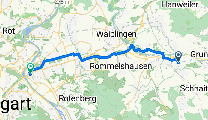
Beutelsbach Bahnhof - Bad-Canstatt Bahnhof
A cycling route starting in Weinstadt-Endersbach, Baden-Württemberg, Germany.
Overview
About this route
Der Start ist in Beutelsbach im Industriegebiet und die Strecke geht über Endersbach - Fellbach - Sommerrain nach Bad-Canstatt.
- -:--
- Duration
- 16.1 km
- Distance
- 83 m
- Ascent
- 89 m
- Descent
- ---
- Avg. speed
- 295 m
- Avg. speed
Route quality
Waytypes & surfaces along the route
Waytypes
Quiet road
5.3 km
(33 %)
Access road
3.4 km
(21 %)
Surfaces
Paved
15.3 km
(95 %)
Asphalt
14.6 km
(91 %)
Paving stones
0.7 km
(4 %)
Continue with Bikemap
Use, edit, or download this cycling route
You would like to ride Beutelsbach Bahnhof - Bad-Canstatt Bahnhof or customize it for your own trip? Here is what you can do with this Bikemap route:
Free features
- Save this route as favorite or in collections
- Copy & plan your own version of this route
- Sync your route with Garmin or Wahoo
Premium features
Free trial for 3 days, or one-time payment. More about Bikemap Premium.
- Navigate this route on iOS & Android
- Export a GPX / KML file of this route
- Create your custom printout (try it for free)
- Download this route for offline navigation
Discover more Premium features.
Get Bikemap PremiumFrom our community
Other popular routes starting in Weinstadt-Endersbach
 Schöne Aussicht Berglen
- Distance
- 50.5 km
- Ascent
- 469 m
- Descent
- 468 m
- Location
- Weinstadt-Endersbach, Baden-Württemberg, Germany
 Rundtour Endersbach
- Distance
- 17.2 km
- Ascent
- 199 m
- Descent
- 200 m
- Location
- Weinstadt-Endersbach, Baden-Württemberg, Germany
 Beutelsbsch- Saffrichhof-Winterbach
- Distance
- 17.7 km
- Ascent
- 306 m
- Descent
- 380 m
- Location
- Weinstadt-Endersbach, Baden-Württemberg, Germany
 Remstal and more
- Distance
- 32.3 km
- Ascent
- 315 m
- Descent
- 315 m
- Location
- Weinstadt-Endersbach, Baden-Württemberg, Germany
 Remshalden - unterhalb Korber Kopf - Buoch-Remshalden
- Distance
- 42.9 km
- Ascent
- 391 m
- Descent
- 393 m
- Location
- Weinstadt-Endersbach, Baden-Württemberg, Germany
 Remstal Weinberge Remshalden - Waiblingen
- Distance
- 31.3 km
- Ascent
- 217 m
- Descent
- 220 m
- Location
- Weinstadt-Endersbach, Baden-Württemberg, Germany
 Grunbach - Schorndorf - Mannshaupten - Königstein - Kreuzeiche - Korber Schützenhaus - Großheppach - Grunbach
- Distance
- 35.9 km
- Ascent
- 594 m
- Descent
- 581 m
- Location
- Weinstadt-Endersbach, Baden-Württemberg, Germany
 Beutelsbach-Schönbühl-Engelberg - Schorndorf -
- Distance
- 39.3 km
- Ascent
- 667 m
- Descent
- 675 m
- Location
- Weinstadt-Endersbach, Baden-Württemberg, Germany
Open it in the app