

13.07.25 Hörschel-Eschwege
A cycling route starting in Krauthausen, Thuringia, Germany.
Overview
About this route
von
<font face="Arial, sans-serif"><font size="2">http://www.bikemap.net/de/route/2290397-130724-bad-salzungen-horschel/?newly_saved=true</font></font> Weitestgehend schöne Wege. Abstecher nach Eisenach. nach <font face="Arial, sans-serif"><font size="2">http://www.bikemap.net/de/route/2290411-130726-eschwege-mengershausen/?newly_saved=true</font></font>- -:--
- Duration
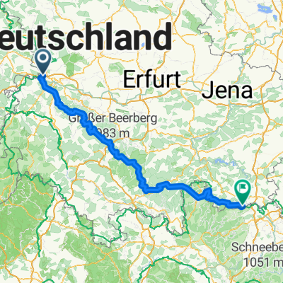
- 77.3 km
- Distance
- 241 m
- Ascent
- 266 m
- Descent
- ---
- Avg. speed
- ---
- Max. altitude

Route quality
Waytypes & surfaces along the route
Waytypes
Quiet road
25.8 km
(33 %)
Track
19.8 km
(26 %)
Surfaces
Paved
56.7 km
(73 %)
Unpaved
9.6 km
(12 %)
Asphalt
48.8 km
(63 %)
Gravel
8.3 km
(11 %)
Route highlights
Points of interest along the route
Point of interest after 24.9 km
Nett gelegenes Café u. Restaurant, ab 12 Uhr.
Point of interest after 55.7 km
Endlich ein geöffnetes Lokal zur Kaffee- u. Trinkpause.
Point of interest after 56.8 km
Getränkenachschub
Point of interest after 67.1 km
Nettes Trinkpausenlokal
Continue with Bikemap
Use, edit, or download this cycling route
You would like to ride 13.07.25 Hörschel-Eschwege or customize it for your own trip? Here is what you can do with this Bikemap route:
Free features
- Save this route as favorite or in collections
- Copy & plan your own version of this route
- Sync your route with Garmin or Wahoo
Premium features
Free trial for 3 days, or one-time payment. More about Bikemap Premium.
- Navigate this route on iOS & Android
- Export a GPX / KML file of this route
- Create your custom printout (try it for free)
- Download this route for offline navigation
Discover more Premium features.
Get Bikemap PremiumFrom our community
Other popular routes starting in Krauthausen
 Trans-Thüringerwald
- Distance
- 186 km
- Ascent
- 2,050 m
- Descent
- 1,757 m
- Location
- Krauthausen, Thuringia, Germany
 Rennsteig Thüringer Wald
- Distance
- 193.1 km
- Ascent
- 1,451 m
- Descent
- 1,247 m
- Location
- Krauthausen, Thuringia, Germany
 13.07.25 Hörschel-Eschwege
- Distance
- 77.3 km
- Ascent
- 241 m
- Descent
- 266 m
- Location
- Krauthausen, Thuringia, Germany
 MB ab Eisenach
- Distance
- 251.6 km
- Ascent
- 4,279 m
- Descent
- 4,215 m
- Location
- Krauthausen, Thuringia, Germany
 Mühlgasse 8, Krauthausen nach Mühlgasse 8, Krauthausen
- Distance
- 27.7 km
- Ascent
- 429 m
- Descent
- 435 m
- Location
- Krauthausen, Thuringia, Germany
 Rennsteig Radweg
- Distance
- 197.5 km
- Ascent
- 1,466 m
- Descent
- 1,237 m
- Location
- Krauthausen, Thuringia, Germany
 Werratal: Hörschel nach Hann. Münden
- Distance
- 110 km
- Ascent
- 227 m
- Descent
- 300 m
- Location
- Krauthausen, Thuringia, Germany
 Rennsteigtour
- Distance
- 184.3 km
- Ascent
- 1,341 m
- Descent
- 1,119 m
- Location
- Krauthausen, Thuringia, Germany
Open it in the app