

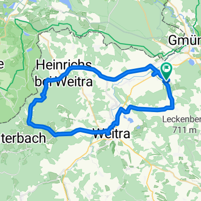
Mandelstein-Alt Weitra-Hörmanns
A cycling route starting in Gmünd, Lower Austria, Austria.
Overview
About this route
<table border="0" cellpadding="0" cellspacing="0" style="width: 1767px;" width="1767" x:str=""> <colgroup> <col /> </colgroup> <tbody> <tr height="17"> <td height="17" style="width: 1767px; height: 17px;"> Guggabergweg - neuer Kindergarten - Unterführung - Dr.-Haus - Wielands - Unter- - Oberlembach - Heinrichs - Mandelstein - Harbach - Wultschau - Weitra - Tiefenbach - Alt Weitra - Hörmanns - Hörmannserstr. - Edelholzstr. - Guggabergweg</td> </tr> </tbody> </table>
- -:--
- Duration
- 35.9 km
- Distance
- 598 m
- Ascent
- 597 m
- Descent
- ---
- Avg. speed
- ---
- Max. altitude

Route quality
Waytypes & surfaces along the route
Waytypes
Road
28.5 km
(80 %)
Quiet road
4.4 km
(12 %)
Surfaces
Paved
10.2 km
(28 %)
Unpaved
0.6 km
(2 %)
Asphalt
10.2 km
(28 %)
Unpaved (undefined)
0.6 km
(2 %)
Undefined
25 km
(70 %)
Continue with Bikemap
Use, edit, or download this cycling route
You would like to ride Mandelstein-Alt Weitra-Hörmanns or customize it for your own trip? Here is what you can do with this Bikemap route:
Free features
- Save this route as favorite or in collections
- Copy & plan your own version of this route
- Sync your route with Garmin or Wahoo
Premium features
Free trial for 3 days, or one-time payment. More about Bikemap Premium.
- Navigate this route on iOS & Android
- Export a GPX / KML file of this route
- Create your custom printout (try it for free)
- Download this route for offline navigation
Discover more Premium features.
Get Bikemap PremiumFrom our community
Other popular routes starting in Gmünd
 Wasserlandschaft 24.09
- Distance
- 80 km
- Ascent
- 790 m
- Descent
- 784 m
- Location
- Gmünd, Lower Austria, Austria
 Neighbour´s visit
- Distance
- 74.2 km
- Ascent
- 726 m
- Descent
- 751 m
- Location
- Gmünd, Lower Austria, Austria
 Trainingsstrecke_1
- Distance
- 57.4 km
- Ascent
- 433 m
- Descent
- 437 m
- Location
- Gmünd, Lower Austria, Austria
 gmünd-krumau-gmünd-krems
- Distance
- 354 km
- Ascent
- 9,631 m
- Descent
- 9,931 m
- Location
- Gmünd, Lower Austria, Austria
 Mandelstein-Alt Weitra-Hörmanns
- Distance
- 35.9 km
- Ascent
- 598 m
- Descent
- 597 m
- Location
- Gmünd, Lower Austria, Austria
 ARBÖ-RC-Gmünd Radtour 1
- Distance
- 51.6 km
- Ascent
- 526 m
- Descent
- 515 m
- Location
- Gmünd, Lower Austria, Austria
 Teichrunde
- Distance
- 81 km
- Ascent
- 238 m
- Descent
- 236 m
- Location
- Gmünd, Lower Austria, Austria
 Mandelstein-Sulz-Weitra
- Distance
- 48.2 km
- Ascent
- 566 m
- Descent
- 566 m
- Location
- Gmünd, Lower Austria, Austria
Open it in the app