

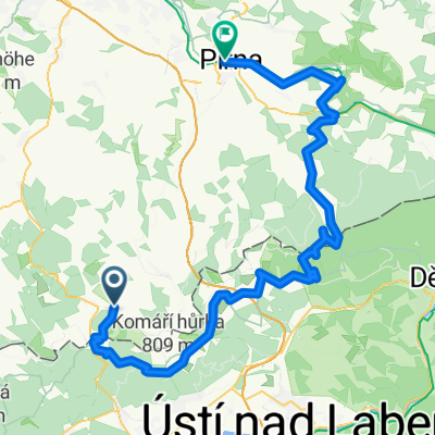
Geising-Mückentürmchen
A cycling route starting in Geising, Saxony, Germany.
Overview
About this route
ruhige, landschaftlich reizvolle Strecke
(cloned from route 2291167)
- -:--
- Duration
- 24.1 km
- Distance
- 464 m
- Ascent
- 464 m
- Descent
- ---
- Avg. speed
- ---
- Max. altitude

Route quality
Waytypes & surfaces along the route
Waytypes
Track
7.6 km
(32 %)
Road
7.1 km
(29 %)
Surfaces
Paved
13.6 km
(56 %)
Unpaved
3.4 km
(14 %)
Asphalt
13.6 km
(56 %)
Gravel
2.2 km
(9 %)
Continue with Bikemap
Use, edit, or download this cycling route
You would like to ride Geising-Mückentürmchen or customize it for your own trip? Here is what you can do with this Bikemap route:
Free features
- Save this route as favorite or in collections
- Copy & plan your own version of this route
- Sync your route with Garmin or Wahoo
Premium features
Free trial for 3 days, or one-time payment. More about Bikemap Premium.
- Navigate this route on iOS & Android
- Export a GPX / KML file of this route
- Create your custom printout (try it for free)
- Download this route for offline navigation
Discover more Premium features.
Get Bikemap PremiumFrom our community
Other popular routes starting in Geising
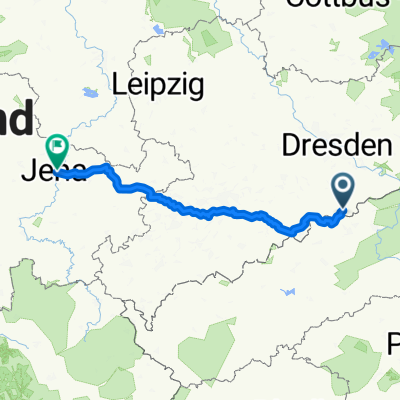 Geising - Jena, 2 Tage
- Distance
- 222.1 km
- Ascent
- 957 m
- Descent
- 1,534 m
- Location
- Geising, Saxony, Germany
 Cínovec-Lesná
- Distance
- 58.1 km
- Ascent
- 677 m
- Descent
- 922 m
- Location
- Geising, Saxony, Germany
 Služebka, Cínovec - DL - Klíny
- Distance
- 33.3 km
- Ascent
- 274 m
- Descent
- 415 m
- Location
- Geising, Saxony, Germany
 ErzgebirgsMAN 2009 NEW!!!
- Distance
- 257.4 km
- Ascent
- 4,193 m
- Descent
- 3,835 m
- Location
- Geising, Saxony, Germany
 tour 200718 vom kamm zur felsenlandschaft
- Distance
- 82.5 km
- Ascent
- 1,053 m
- Descent
- 1,525 m
- Location
- Geising, Saxony, Germany
 Fürstenwalde Umrundung
- Distance
- 20.8 km
- Ascent
- 343 m
- Descent
- 345 m
- Location
- Geising, Saxony, Germany
 Geising-Mückentürmchen
- Distance
- 24.1 km
- Ascent
- 464 m
- Descent
- 464 m
- Location
- Geising, Saxony, Germany
 VKHč.1 Furstenau- NSG Fu.Heide- Traugothohe- Kohlhaukuppe-Zinwald-Cínovec-Cínovecký hřbet-
- Distance
- 14.8 km
- Ascent
- 301 m
- Descent
- 313 m
- Location
- Geising, Saxony, Germany
Open it in the app