

MTB Hornussen 2013 60 km
A cycling route starting in Frick, Canton of Aargau, Switzerland.
Overview
About this route
Start / finish at Honussen school, nearly 60 km long, about 1750 meters of elevation gain, very varied ups and downs, great views, about 50% paved roads - 50% unpaved paths, few refreshment stops along the way
- -:--
- Duration
- 56.9 km
- Distance
- 1,372 m
- Ascent
- 1,372 m
- Descent
- ---
- Avg. speed
- ---
- Max. altitude
Route quality
Waytypes & surfaces along the route
Waytypes
Track
37.6 km
(66 %)
Quiet road
14.2 km
(25 %)
Surfaces
Paved
18.8 km
(33 %)
Unpaved
28.5 km
(50 %)
Gravel
24.5 km
(43 %)
Asphalt
10.8 km
(19 %)
Continue with Bikemap
Use, edit, or download this cycling route
You would like to ride MTB Hornussen 2013 60 km or customize it for your own trip? Here is what you can do with this Bikemap route:
Free features
- Save this route as favorite or in collections
- Copy & plan your own version of this route
- Sync your route with Garmin or Wahoo
Premium features
Free trial for 3 days, or one-time payment. More about Bikemap Premium.
- Navigate this route on iOS & Android
- Export a GPX / KML file of this route
- Create your custom printout (try it for free)
- Download this route for offline navigation
Discover more Premium features.
Get Bikemap PremiumFrom our community
Other popular routes starting in Frick
 Recovered Route
- Distance
- 52.3 km
- Ascent
- 396 m
- Descent
- 462 m
- Location
- Frick, Canton of Aargau, Switzerland
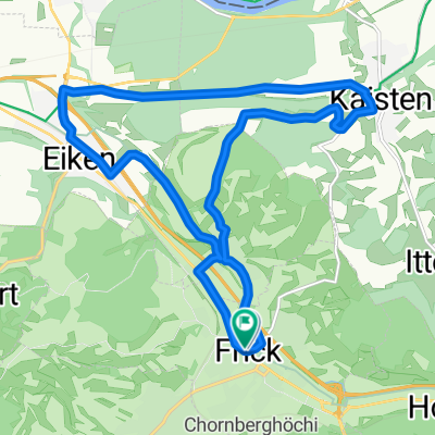 Frick Kaisten Eiken
- Distance
- 16.2 km
- Ascent
- 208 m
- Descent
- 206 m
- Location
- Frick, Canton of Aargau, Switzerland
 frick - gansingen
- Distance
- 25 km
- Ascent
- 491 m
- Descent
- 422 m
- Location
- Frick, Canton of Aargau, Switzerland
 Bözen-Bözberg-Leuggern-Hottwil-Mönthal-Bözen
- Distance
- 43.3 km
- Ascent
- 634 m
- Descent
- 621 m
- Location
- Frick, Canton of Aargau, Switzerland
 Abendgenuss im Eisenland Herznach Frick AG
- Distance
- 16.6 km
- Ascent
- 268 m
- Descent
- 268 m
- Location
- Frick, Canton of Aargau, Switzerland
 1. Etappe Frick - Lenzkirch
- Distance
- 87.4 km
- Ascent
- 1,244 m
- Descent
- 747 m
- Location
- Frick, Canton of Aargau, Switzerland
 Sunday Trip
- Distance
- 25.5 km
- Ascent
- 190 m
- Descent
- 212 m
- Location
- Frick, Canton of Aargau, Switzerland
 Fricktaler Huegelvergnuege Abendtraining
- Distance
- 27.8 km
- Ascent
- 406 m
- Descent
- 345 m
- Location
- Frick, Canton of Aargau, Switzerland
Open it in the app