

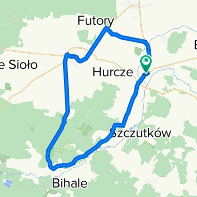
Południowe Roztocze w terenie
A cycling route starting in Lubaczów, Subcarpathian Voivodeship, Poland.
Overview
About this route
Asfaltowo terenowa trasa północno-wschodnimi krańcami województwa podkarpackiego.
- -:--
- Duration
- 51.2 km
- Distance
- 198 m
- Ascent
- 198 m
- Descent
- ---
- Avg. speed
- ---
- Max. altitude

Route quality
Waytypes & surfaces along the route
Waytypes
Track
16.4 km
(32 %)
Quiet road
15.1 km
(30 %)
Surfaces
Paved
32.2 km
(63 %)
Unpaved
13 km
(25 %)
Asphalt
30 km
(59 %)
Unpaved (undefined)
6.1 km
(12 %)
Continue with Bikemap
Use, edit, or download this cycling route
You would like to ride Południowe Roztocze w terenie or customize it for your own trip? Here is what you can do with this Bikemap route:
Free features
- Save this route as favorite or in collections
- Copy & plan your own version of this route
- Sync your route with Garmin or Wahoo
Premium features
Free trial for 3 days, or one-time payment. More about Bikemap Premium.
- Navigate this route on iOS & Android
- Export a GPX / KML file of this route
- Create your custom printout (try it for free)
- Download this route for offline navigation
Discover more Premium features.
Get Bikemap PremiumFrom our community
Other popular routes starting in Lubaczów
 Lubaczów - Tomaszów Lubelski (80 km)
- Distance
- 79.9 km
- Ascent
- 371 m
- Descent
- 312 m
- Location
- Lubaczów, Subcarpathian Voivodeship, Poland
 Lubaczów - Rzeszów szosa!
- Distance
- 100.2 km
- Ascent
- 274 m
- Descent
- 278 m
- Location
- Lubaczów, Subcarpathian Voivodeship, Poland
 Recovered Route
- Distance
- 34.7 km
- Ascent
- 190 m
- Descent
- 195 m
- Location
- Lubaczów, Subcarpathian Voivodeship, Poland
 krasnobrod
- Distance
- 125.6 km
- Ascent
- 378 m
- Descent
- 375 m
- Location
- Lubaczów, Subcarpathian Voivodeship, Poland
 Szlakiem mych Przodków Cisowskich (1920-1835)
- Distance
- 205 km
- Ascent
- 573 m
- Descent
- 572 m
- Location
- Lubaczów, Subcarpathian Voivodeship, Poland
 Akacjowa 24, Lubaczów do 71A, Wólka Horyniecka
- Distance
- 25.6 km
- Ascent
- 110 m
- Descent
- 75 m
- Location
- Lubaczów, Subcarpathian Voivodeship, Poland
 Roztocze asfaltem i przez las w 2 dni
- Distance
- 187.1 km
- Ascent
- 379 m
- Descent
- 379 m
- Location
- Lubaczów, Subcarpathian Voivodeship, Poland
 Południowe Roztocze w terenie
- Distance
- 51.2 km
- Ascent
- 198 m
- Descent
- 198 m
- Location
- Lubaczów, Subcarpathian Voivodeship, Poland
Open it in the app