
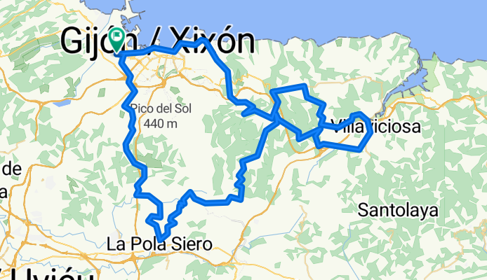
GIJON - POLA SIERO - VILLAVICIOSA - GIJON
A cycling route starting in Natahoyo, Principality of Asturias, Spain.
Overview
About this route
Salida desde el Cerillero en dirección a Tremañes para coger la senda verde de La Camocha hasta enlazar en la gasolinera que nos deja a los pies de la subida al Alto de la Madera. (AS-246)<br /> <br /> Una vez que estamos bajando dirección Noreña nos desviamos bajo el viaducto de la autopista para enlazar con la SI-15 y posteriormente por carreteras secundarias llegar hasta las afueras de POLA SIERO donde giramos para coger la AS-248 y comenzar la Subida al Munco, la cual abandonaremos cuando encontremos una parada de autobus y una carretera que indica la collada de atras, la cual nos servira de enlace con la AS-331 para coronar el Alto de la Fumarea.<br /> <br /> Descendida la AS-331 nos presentamos en Peon para ascender al cordar y en la bajada nos desviamos direccion Nievares (VV-8,VV-9,VV-10) hasta enganchar la AS-267 que nos llevara a VILLAVICIOSA y de ahi por la N-632 para subir El Pedrosu y continuar hasta GIJÓN.<br /> <br /> Escasos Kilometros despues de la Venta las Ranas tomamos por el margen izquierdo la VV-7 para volver a Peón y subir El Curbiello (AS-331) una vez llegados al cruce del Alto del Infanzón nos dirigimos hacía la AS-247 y posteriormente la GI-2 para llegar a GIJÓN descendiendo el Alto de la Providencia y terminar cruzando la ciudad para llegar al punto de inicio (El Cerillero).
- -:--
- Duration
- 99 km
- Distance
- 1,506 m
- Ascent
- 1,506 m
- Descent
- ---
- Avg. speed
- ---
- Avg. speed

Route quality
Waytypes & surfaces along the route
Waytypes
Road
58.9 km
(59 %)
Cycleway
16.1 km
(16 %)
Surfaces
Paved
81.2 km
(82 %)
Unpaved
1 km
(1 %)
Asphalt
80.6 km
(81 %)
Gravel
0.9 km
(<1 %)
Continue with Bikemap
Use, edit, or download this cycling route
You would like to ride GIJON - POLA SIERO - VILLAVICIOSA - GIJON or customize it for your own trip? Here is what you can do with this Bikemap route:
Free features
- Save this route as favorite or in collections
- Copy & plan your own version of this route
- Split it into stages to create a multi-day tour
- Sync your route with Garmin or Wahoo
Premium features
Free trial for 3 days, or one-time payment. More about Bikemap Premium.
- Navigate this route on iOS & Android
- Export a GPX / KML file of this route
- Create your custom printout (try it for free)
- Download this route for offline navigation
Discover more Premium features.
Get Bikemap PremiumFrom our community
Other popular routes starting in Natahoyo
 Gijon - Nantes
- Distance
- 1,267.4 km
- Ascent
- 1,024 m
- Descent
- 1,014 m
- Location
- Natahoyo, Principality of Asturias, Spain
 Gijón/Xixón
- Distance
- 24.4 km
- Ascent
- 151 m
- Descent
- 152 m
- Location
- Natahoyo, Principality of Asturias, Spain
 Gijón-Santiago
- Distance
- 318.8 km
- Ascent
- 1,509 m
- Descent
- 1,236 m
- Location
- Natahoyo, Principality of Asturias, Spain
![Vuelta a Asturias 2010 - Et.03. 1ºSector [Gijon - Aviles]](https://media.bikemap.net/routes/585301/staticmaps/in_8ab1d5f9-292a-49df-8920-335db6124f1c_400x400_bikemap-2021-3D-static.png) Vuelta a Asturias 2010 - Et.03. 1ºSector [Gijon - Aviles]
Vuelta a Asturias 2010 - Et.03. 1ºSector [Gijon - Aviles]- Distance
- 89.3 km
- Ascent
- 954 m
- Descent
- 964 m
- Location
- Natahoyo, Principality of Asturias, Spain
 Playas de Gijón
- Distance
- 4 km
- Ascent
- 74 m
- Descent
- 76 m
- Location
- Natahoyo, Principality of Asturias, Spain
 Candás
- Distance
- 14.9 km
- Ascent
- 351 m
- Descent
- 358 m
- Location
- Natahoyo, Principality of Asturias, Spain
 SALIDA PYNOSPERDIUS 24/03/12
- Distance
- 105.7 km
- Ascent
- 2,170 m
- Descent
- 2,177 m
- Location
- Natahoyo, Principality of Asturias, Spain
 XATADA PYNOSPERDIUS
- Distance
- 114.3 km
- Ascent
- 2,632 m
- Descent
- 2,635 m
- Location
- Natahoyo, Principality of Asturias, Spain
Open it in the app