Šentjur - Celjska koča čez Svetino, povratek čez brda nad Štorami
A cycling route starting in Šentjur pri Celju, Šentjur Municipality, Slovenia.
Overview
About this route
Very varied tour, a lot through the forest, without main roads. Some very steep sections, especially on the return from Celjska koča between Zagrad and Štorami.
- -:--
- Duration
- 45.3 km
- Distance
- 811 m
- Ascent
- 811 m
- Descent
- ---
- Avg. speed
- ---
- Max. altitude
Route quality
Waytypes & surfaces along the route
Waytypes
Quiet road
28.5 km
(63 %)
Road
9.5 km
(21 %)
Undefined
7.2 km
(16 %)
Surfaces
Paved
17.7 km
(39 %)
Unpaved
0.5 km
(1 %)
Asphalt
13.1 km
(29 %)
Paved (undefined)
4.5 km
(10 %)
Route highlights
Points of interest along the route
Point of interest after 23.4 km
Celjska koča
Continue with Bikemap
Use, edit, or download this cycling route
You would like to ride Šentjur - Celjska koča čez Svetino, povratek čez brda nad Štorami or customize it for your own trip? Here is what you can do with this Bikemap route:
Free features
- Save this route as favorite or in collections
- Copy & plan your own version of this route
- Sync your route with Garmin or Wahoo
Premium features
Free trial for 3 days, or one-time payment. More about Bikemap Premium.
- Navigate this route on iOS & Android
- Export a GPX / KML file of this route
- Create your custom printout (try it for free)
- Download this route for offline navigation
Discover more Premium features.
Get Bikemap PremiumFrom our community
Other popular routes starting in Šentjur pri Celju
- Šentjur - Celjska koča čez Svetino, povratek čez brda nad Štorami
- Distance
- 45.3 km
- Ascent
- 811 m
- Descent
- 811 m
- Location
- Šentjur pri Celju, Šentjur Municipality, Slovenia
- Kozjansko - Panoramska (B)
- Distance
- 45.1 km
- Ascent
- 1,083 m
- Descent
- 1,082 m
- Location
- Šentjur pri Celju, Šentjur Municipality, Slovenia
- Okrog Slivniškega jezera s štartom in ciljem v Šentjurju pri OŠ FM
- Distance
- 18.2 km
- Ascent
- 220 m
- Descent
- 223 m
- Location
- Šentjur pri Celju, Šentjur Municipality, Slovenia
- Slivniško jezero
- Distance
- 8.3 km
- Ascent
- 224 m
- Descent
- 223 m
- Location
- Šentjur pri Celju, Šentjur Municipality, Slovenia
- Šentjur-šentrupert-laško-svetina-šentjur
- Distance
- 41.9 km
- Ascent
- 885 m
- Descent
- 885 m
- Location
- Šentjur pri Celju, Šentjur Municipality, Slovenia
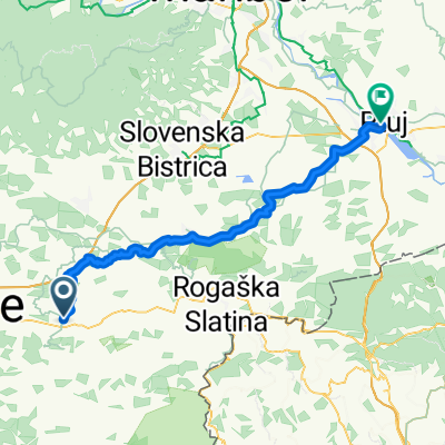
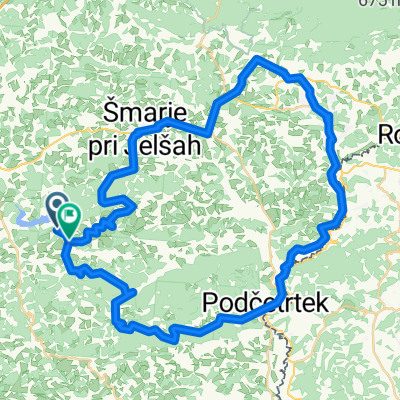
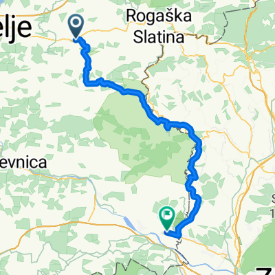
- Sotensko pod Kalobjem 3 nach Rifnik und zurück
- Distance
- 9.9 km
- Ascent
- 356 m
- Descent
- 357 m
- Location
- Šentjur pri Celju, Šentjur Municipality, Slovenia
- Kozjansko - Turistična (C)
- Distance
- 56.1 km
- Ascent
- 891 m
- Descent
- 890 m
- Location
- Šentjur pri Celju, Šentjur Municipality, Slovenia
- Gregor 11
- Distance
- 16.5 km
- Ascent
- 585 m
- Descent
- 591 m
- Location
- Šentjur pri Celju, Šentjur Municipality, Slovenia
Open it in the app