

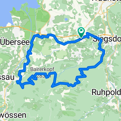
Brachtalm, Runde mit Umwegen
A cycling route starting in Bergen, Bavaria, Germany.
Overview
About this route
Loop from Kohlstadt to Brachtalm, with detours to lengthen the tour a bit and to avoid the very steep short climb. Thus, an excellent after-work loop. At the top, a short trail through marshy terrain on wooden planks, always a joy. Great snacks, very nice hosts.
- -:--
- Duration
- 15.9 km
- Distance
- 766 m
- Ascent
- 766 m
- Descent
- ---
- Avg. speed
- ---
- Max. altitude

Route highlights
Points of interest along the route
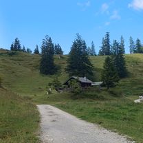
Point of interest after 11.6 km
Brachtalm, sehr nette Wirtsleut!!
Continue with Bikemap
Use, edit, or download this cycling route
You would like to ride Brachtalm, Runde mit Umwegen or customize it for your own trip? Here is what you can do with this Bikemap route:
Free features
- Save this route as favorite or in collections
- Copy & plan your own version of this route
- Sync your route with Garmin or Wahoo
Premium features
Free trial for 3 days, or one-time payment. More about Bikemap Premium.
- Navigate this route on iOS & Android
- Export a GPX / KML file of this route
- Create your custom printout (try it for free)
- Download this route for offline navigation
Discover more Premium features.
Get Bikemap PremiumFrom our community
Other popular routes starting in Bergen
 Umrundung Hochfelln - Bründlingalm - Eschlmoosalm - Engelsstein
- Distance
- 34.8 km
- Ascent
- 1,246 m
- Descent
- 1,246 m
- Location
- Bergen, Bavaria, Germany
 Bergen-Kochel
- Distance
- 164.9 km
- Ascent
- 1,520 m
- Descent
- 1,493 m
- Location
- Bergen, Bavaria, Germany
 Bründlingalm
- Distance
- 17.5 km
- Ascent
- 666 m
- Descent
- 663 m
- Location
- Bergen, Bavaria, Germany
 Bründling Alm Runde Nr 66
- Distance
- 18.3 km
- Ascent
- 882 m
- Descent
- 909 m
- Location
- Bergen, Bavaria, Germany
 Umrundung Hochfelln mit Bründlingalm und Engelstein CLONED FROM ROUTE 494893
- Distance
- 35.6 km
- Ascent
- 1,417 m
- Descent
- 1,417 m
- Location
- Bergen, Bavaria, Germany
 Panoramarunde_active_Bergen
- Distance
- 20.7 km
- Ascent
- 738 m
- Descent
- 738 m
- Location
- Bergen, Bavaria, Germany
 Hochgern Umrundung
- Distance
- 36 km
- Ascent
- 919 m
- Descent
- 919 m
- Location
- Bergen, Bavaria, Germany
 Bergener Panoramatour
- Distance
- 46.5 km
- Ascent
- 1,056 m
- Descent
- 1,063 m
- Location
- Bergen, Bavaria, Germany
Open it in the app