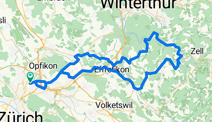
Oerlikon_Kyburg
A cycling route starting in Zürich (Kreis 12) / Saatlen, Canton of Zurich, Switzerland.
Overview
About this route
Hagenholzstrasse -Kyburg retour ... heute ausprobieren
- -:--
- Duration
- 55.5 km
- Distance
- 579 m
- Ascent
- 581 m
- Descent
- ---
- Avg. speed
- ---
- Max. altitude
Route quality
Waytypes & surfaces along the route
Waytypes
- Road - 30.5 km - (55 %) 
- Path - 5.6 km - (10 %) 
Surfaces
Paved
50 km
(90 %)
- Asphalt - 50 km - (90 %) 
- Undefined - 5.6 km - (10 %) 
Continue with Bikemap
Use, edit, or download this cycling route
You would like to ride Oerlikon_Kyburg or customize it for your own trip? Here is what you can do with this Bikemap route:
Free features
- Save this route as favorite or in collections
- Copy & plan your own version of this route
- Sync your route with Garmin or Wahoo
Premium features
Free trial for 3 days, or one-time payment. More about Bikemap Premium.
- Navigate this route on iOS & Android
- Export a GPX / KML file of this route
- Create your custom printout (try it for free)
- Download this route for offline navigation
Discover more Premium features.
Get Bikemap PremiumFrom our community
Other popular routes starting in Zürich (Kreis 12) / Saatlen
 60km - ZH Nord - Pfäffikersee - Greifensee 60km - ZH Nord - Pfäffikersee - Greifensee- Distance
- 58.8 km
- Ascent
- 367 m
- Descent
- 366 m
- Location
- Zürich (Kreis 12) / Saatlen, Canton of Zurich, Switzerland
 
 Oerlikon_Kyburg Oerlikon_Kyburg- Distance
- 55.5 km
- Ascent
- 579 m
- Descent
- 581 m
- Location
- Zürich (Kreis 12) / Saatlen, Canton of Zurich, Switzerland
 
 Beautiful lake cycle..... Beautiful lake cycle.....- Distance
- 29.1 km
- Ascent
- 32 m
- Descent
- 31 m
- Location
- Zürich (Kreis 12) / Saatlen, Canton of Zurich, Switzerland
 
 Breiter-Greifen Breiter-Greifen- Distance
- 46 km
- Ascent
- 184 m
- Descent
- 184 m
- Location
- Zürich (Kreis 12) / Saatlen, Canton of Zurich, Switzerland
 
 1 mal dur Schwiiz 1 mal dur Schwiiz- Distance
- 331.7 km
- Ascent
- 4,184 m
- Descent
- 2,704 m
- Location
- Zürich (Kreis 12) / Saatlen, Canton of Zurich, Switzerland
 
 Hubenstrasse 24–26, Zürich nach Talgartenstrasse 15, Illnau Hubenstrasse 24–26, Zürich nach Talgartenstrasse 15, Illnau- Distance
- 15.6 km
- Ascent
- 1,118 m
- Descent
- 1,080 m
- Location
- Zürich (Kreis 12) / Saatlen, Canton of Zurich, Switzerland
 
 Route zu Open Ride Route zu Open Ride- Distance
- 6.6 km
- Ascent
- 68 m
- Descent
- 85 m
- Location
- Zürich (Kreis 12) / Saatlen, Canton of Zurich, Switzerland
 
 zurUBS_viaEuropabrücke zurUBS_viaEuropabrücke- Distance
- 8.1 km
- Ascent
- 101 m
- Descent
- 131 m
- Location
- Zürich (Kreis 12) / Saatlen, Canton of Zurich, Switzerland
 
Open it in the app


