

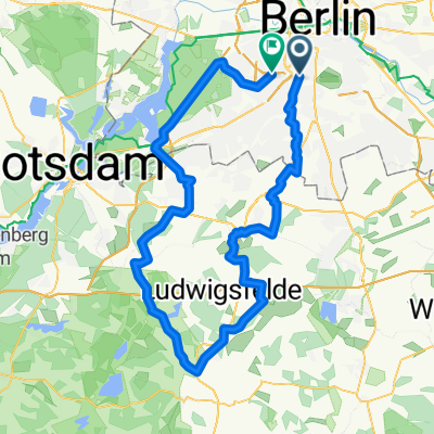
Südkreuz - Gröben - Teltowkanalradweg - Innsbrucker Platz
A cycling route starting in Schöneberg, State of Berlin, Germany.
Overview
About this route
Tour over quiet streets, good accompanying bike paths and the Teltow Canal bike path. It is not completely paved, but fully suitable for racing bikes. Some short cobbled sections on the way - that's just the price of the quiet route. :-)
- -:--
- Duration
- 78 km
- Distance
- 117 m
- Ascent
- 118 m
- Descent
- ---
- Avg. speed
- ---
- Max. altitude

Route quality
Waytypes & surfaces along the route
Waytypes
Quiet road
31.2 km
(40 %)
Road
17.9 km
(23 %)
Surfaces
Paved
67.9 km
(87 %)
Unpaved
4.7 km
(6 %)
Asphalt
65.5 km
(84 %)
Concrete
2.3 km
(3 %)
Route highlights
Points of interest along the route
Point of interest after 42.6 km
Gasthof Naase... Pause!
Continue with Bikemap
Use, edit, or download this cycling route
You would like to ride Südkreuz - Gröben - Teltowkanalradweg - Innsbrucker Platz or customize it for your own trip? Here is what you can do with this Bikemap route:
Free features
- Save this route as favorite or in collections
- Copy & plan your own version of this route
- Sync your route with Garmin or Wahoo
Premium features
Free trial for 3 days, or one-time payment. More about Bikemap Premium.
- Navigate this route on iOS & Android
- Export a GPX / KML file of this route
- Create your custom printout (try it for free)
- Download this route for offline navigation
Discover more Premium features.
Get Bikemap PremiumFrom our community
Other popular routes starting in Schöneberg
 Rund um Berlin 2015
- Distance
- 231.7 km
- Ascent
- 180 m
- Descent
- 180 m
- Location
- Schöneberg, State of Berlin, Germany
 Südkreuz - Lichtenrade - Jühnsdorf - Christinendorf - Trebbin - Dobbrikow - Michendorf - Caputh - Potsdam - Wannsee - Bundesplatz
- Distance
- 116.7 km
- Ascent
- 145 m
- Descent
- 141 m
- Location
- Schöneberg, State of Berlin, Germany
 Südkreuz -> Selchow -> Mittenwalde -> Mauer von Telz -> Ludwigsfelde -> Neubeeren -> Stahnsdorf -> Wannsee -> Bundesplatz
- Distance
- 103.8 km
- Ascent
- 133 m
- Descent
- 129 m
- Location
- Schöneberg, State of Berlin, Germany
 Südkreuz - THF - SXF - Groß Schulzendorf - Genshagen - Siethen - Gröben - Drewitz - Wannsee - Auerbachtunnel
- Distance
- 92.9 km
- Ascent
- 146 m
- Descent
- 137 m
- Location
- Schöneberg, State of Berlin, Germany
 Südrunde via Fuchsberg, Kleinbeeren, Lankwitz
- Distance
- 62.4 km
- Ascent
- 83 m
- Descent
- 85 m
- Location
- Schöneberg, State of Berlin, Germany
 Feierabendrunde ab Südkreuz / 2x über den Fuchsberg
- Distance
- 57.9 km
- Ascent
- 99 m
- Descent
- 100 m
- Location
- Schöneberg, State of Berlin, Germany
 Südkreuz - Gröben - Teltowkanalradweg - Innsbrucker Platz
- Distance
- 78 km
- Ascent
- 117 m
- Descent
- 118 m
- Location
- Schöneberg, State of Berlin, Germany
 Thyrowrunde
- Distance
- 86.6 km
- Ascent
- 136 m
- Descent
- 129 m
- Location
- Schöneberg, State of Berlin, Germany
Open it in the app