Santa Cruz Mntn Loop from SC
A cycling route starting in Twin Lakes, California, United States of America.
Overview
About this route
Felton, Zayante, Bear Creek, Black and back
- -:--
- Duration
- 86.6 km
- Distance
- 1,459 m
- Ascent
- 1,458 m
- Descent
- ---
- Avg. speed
- ---
- Avg. speed
Route quality
Waytypes & surfaces along the route
Waytypes
Busy road
56.4 km
(65 %)
Road
25.6 km
(30 %)
Surfaces
Paved
67.5 km
(78 %)
Asphalt
67.2 km
(78 %)
Concrete
0.2 km
(<1 %)
Undefined
19.2 km
(22 %)
Continue with Bikemap
Use, edit, or download this cycling route
You would like to ride Santa Cruz Mntn Loop from SC or customize it for your own trip? Here is what you can do with this Bikemap route:
Free features
- Save this route as favorite or in collections
- Copy & plan your own version of this route
- Sync your route with Garmin or Wahoo
Premium features
Free trial for 3 days, or one-time payment. More about Bikemap Premium.
- Navigate this route on iOS & Android
- Export a GPX / KML file of this route
- Create your custom printout (try it for free)
- Download this route for offline navigation
Discover more Premium features.
Get Bikemap PremiumFrom our community
Other popular routes starting in Twin Lakes
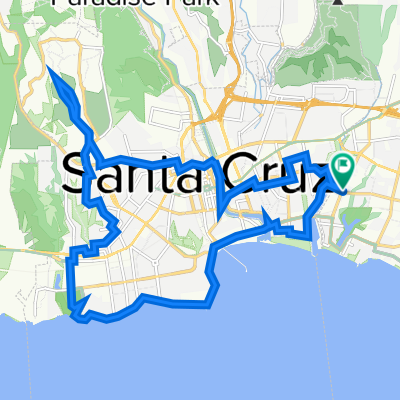
- Eureka canyon loop from SC Harbor
- Distance
- 78.9 km
- Ascent
- 794 m
- Descent
- 801 m
- Location
- Twin Lakes, California, United States of America
- Seabright Bike Night
- Distance
- 13 km
- Ascent
- 89 m
- Descent
- 88 m
- Location
- Twin Lakes, California, United States of America
- Browns Valley Loop
- Distance
- 74.2 km
- Ascent
- 598 m
- Descent
- 598 m
- Location
- Twin Lakes, California, United States of America
- Santa Cruz to San Mateo Route Hwy 9/Skyline
- Distance
- 105.3 km
- Ascent
- 1,234 m
- Descent
- 1,252 m
- Location
- Twin Lakes, California, United States of America
- USA : SF - San Diego
- Distance
- 522.6 km
- Ascent
- 1,324 m
- Descent
- 1,316 m
- Location
- Twin Lakes, California, United States of America
- SC Mt Charlie Black Mtn Zayante
- Distance
- 84.1 km
- Ascent
- 1,269 m
- Descent
- 1,271 m
- Location
- Twin Lakes, California, United States of America
- Kendall’s ride
- Distance
- 52.8 km
- Ascent
- 487 m
- Descent
- 489 m
- Location
- Twin Lakes, California, United States of America
- Santa Cruz Mntn Loop from SC
- Distance
- 86.6 km
- Ascent
- 1,459 m
- Descent
- 1,458 m
- Location
- Twin Lakes, California, United States of America
Open it in the app