
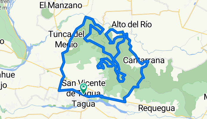
Rally San Vicente XCM 2013
A cycling route starting in San Vicente de Tagua Tagua, O'Higgins Region, Chile.
Overview
About this route
Rally San Vicente XCM 2013
- -:--
- Duration
- 53.8 km
- Distance
- 866 m
- Ascent
- 865 m
- Descent
- ---
- Avg. speed
- ---
- Max. altitude

Continue with Bikemap
Use, edit, or download this cycling route
You would like to ride Rally San Vicente XCM 2013 or customize it for your own trip? Here is what you can do with this Bikemap route:
Free features
- Save this route as favorite or in collections
- Copy & plan your own version of this route
- Sync your route with Garmin or Wahoo
Premium features
Free trial for 3 days, or one-time payment. More about Bikemap Premium.
- Navigate this route on iOS & Android
- Export a GPX / KML file of this route
- Create your custom printout (try it for free)
- Download this route for offline navigation
Discover more Premium features.
Get Bikemap PremiumFrom our community
Other popular routes starting in San Vicente de Tagua Tagua
 millahue
- Distance
- 25 km
- Ascent
- 95 m
- Descent
- 112 m
- Location
- San Vicente de Tagua Tagua, O'Higgins Region, Chile
 probando app
- Distance
- 24.7 km
- Ascent
- 901 m
- Descent
- 899 m
- Location
- San Vicente de Tagua Tagua, O'Higgins Region, Chile
 De Francia 1119, San Vicente de Taguatagua a Francia 1119, San Vicente de Taguatagua
- Distance
- 19.5 km
- Ascent
- 75 m
- Descent
- 38 m
- Location
- San Vicente de Tagua Tagua, O'Higgins Region, Chile
 De Callejón Tiralarga 54, San Vicente de Taguatagua a Francia 1119, San Vicente de Taguatagua
- Distance
- 20.3 km
- Ascent
- 106 m
- Descent
- 109 m
- Location
- San Vicente de Tagua Tagua, O'Higgins Region, Chile
 Raquegua a Ruta 66
- Distance
- 27.6 km
- Ascent
- 1 m
- Descent
- 1 m
- Location
- San Vicente de Tagua Tagua, O'Higgins Region, Chile
 Paseito por Sta.Ines-Antivero-El Tambo
- Distance
- 16.5 km
- Ascent
- 71 m
- Descent
- 72 m
- Location
- San Vicente de Tagua Tagua, O'Higgins Region, Chile
 11)Salsipuedes-Angol
- Distance
- 622.1 km
- Ascent
- 1,652 m
- Descent
- 1,837 m
- Location
- San Vicente de Tagua Tagua, O'Higgins Region, Chile
 Rally San Vicente XCM 2013
- Distance
- 53.8 km
- Ascent
- 866 m
- Descent
- 865 m
- Location
- San Vicente de Tagua Tagua, O'Higgins Region, Chile
Open it in the app