

hkhk
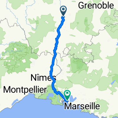
A cycling route starting in La Roche-de-Glun, Auvergne-Rhône-Alpes, France.
Overview
About this route
hkhk
- -:--
- Duration
- 113.4 km
- Distance
- 725 m
- Ascent
- 221 m
- Descent
- ---
- Avg. speed
- ---
- Max. altitude
Route quality
Waytypes & surfaces along the route
Waytypes
Quiet road
13.6 km
(12 %)
Road
10.2 km
(9 %)
Surfaces
Paved
85.1 km
(75 %)
Unpaved
1.1 km
(1 %)
Asphalt
82.8 km
(73 %)
Paved (undefined)
1.1 km
(1 %)
Continue with Bikemap
Use, edit, or download this cycling route
You would like to ride hkhk or customize it for your own trip? Here is what you can do with this Bikemap route:
Free features
- Save this route as favorite or in collections
- Copy & plan your own version of this route
- Split it into stages to create a multi-day tour
- Sync your route with Garmin or Wahoo
Premium features
Free trial for 3 days, or one-time payment. More about Bikemap Premium.
- Navigate this route on iOS & Android
- Export a GPX / KML file of this route
- Create your custom printout (try it for free)
- Download this route for offline navigation
Discover more Premium features.
Get Bikemap PremiumFrom our community
Other popular routes starting in La Roche-de-Glun
 Etape 3 : La Roche de Glun ==> Montélimar
- Distance
- 79 km
- Ascent
- 75 m
- Descent
- 110 m
- Location
- La Roche-de-Glun, Auvergne-Rhône-Alpes, France
 Valence-Marseille
- Distance
- 240.8 km
- Ascent
- 817 m
- Descent
- 907 m
- Location
- La Roche-de-Glun, Auvergne-Rhône-Alpes, France
 Sur les routes de l'Ardèchoise (1)
- Distance
- 166 km
- Ascent
- 2,150 m
- Descent
- 2,150 m
- Location
- La Roche-de-Glun, Auvergne-Rhône-Alpes, France
 ETAPPE 8 - Châteauneuf-sur-Isère nach Mondragon
- Distance
- 121.4 km
- Ascent
- 363 m
- Descent
- 439 m
- Location
- La Roche-de-Glun, Auvergne-Rhône-Alpes, France
 La Roche-De-Glun til Pont St-Esperit
- Distance
- 123.5 km
- Ascent
- 165 m
- Descent
- 232 m
- Location
- La Roche-de-Glun, Auvergne-Rhône-Alpes, France
 De Rue de l'Église 16, Glun à Rue de l'Église 16, Glun
- Distance
- 50.4 km
- Ascent
- 165 m
- Descent
- 162 m
- Location
- La Roche-de-Glun, Auvergne-Rhône-Alpes, France
 Valence-Monaco Flaka+Stephi
- Distance
- 573.5 km
- Ascent
- 7,391 m
- Descent
- 7,501 m
- Location
- La Roche-de-Glun, Auvergne-Rhône-Alpes, France
 Glun Glun 19 avril
- Distance
- 24.3 km
- Ascent
- 49 m
- Descent
- 51 m
- Location
- La Roche-de-Glun, Auvergne-Rhône-Alpes, France
Open it in the app