
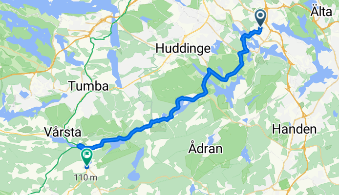
Farsta - Rosenhill
A cycling route starting in Älta, Stockholm County, Sweden.
Overview
About this route
En rutt som fungerar med mtb eller cyclocross, avslutas med ett fik värt en resa.
- -:--
- Duration
- 27.1 km
- Distance
- 256 m
- Ascent
- 278 m
- Descent
- ---
- Avg. speed
- ---
- Max. altitude
Route quality
Waytypes & surfaces along the route
Waytypes
Quiet road
14.6 km
(54 %)
Cycleway
4.6 km
(17 %)
Surfaces
Paved
11.7 km
(43 %)
Unpaved
12.7 km
(47 %)
Gravel
9 km
(33 %)
Asphalt
8.7 km
(32 %)
Continue with Bikemap
Use, edit, or download this cycling route
You would like to ride Farsta - Rosenhill or customize it for your own trip? Here is what you can do with this Bikemap route:
Free features
- Save this route as favorite or in collections
- Copy & plan your own version of this route
- Sync your route with Garmin or Wahoo
Premium features
Free trial for 3 days, or one-time payment. More about Bikemap Premium.
- Navigate this route on iOS & Android
- Export a GPX / KML file of this route
- Create your custom printout (try it for free)
- Download this route for offline navigation
Discover more Premium features.
Get Bikemap PremiumFrom our community
Other popular routes starting in Älta
 Farsta - Rosenhill
- Distance
- 27.1 km
- Ascent
- 256 m
- Descent
- 278 m
- Location
- Älta, Stockholm County, Sweden
 N. Sköndal-Huddinge-Tullinge-Grindsjön-Tungelsta-Haninge-Sköndal
- Distance
- 76.9 km
- Ascent
- 284 m
- Descent
- 284 m
- Location
- Älta, Stockholm County, Sweden
 Tyrestarundan
- Distance
- 51.3 km
- Ascent
- 254 m
- Descent
- 254 m
- Location
- Älta, Stockholm County, Sweden
 Skarpnäck-Huddinge-Lissma-Länna-Skarpnäck
- Distance
- 39.8 km
- Ascent
- 183 m
- Descent
- 183 m
- Location
- Älta, Stockholm County, Sweden
 Sköndal-Huddinge-Lissma-Länna-Sköndal
- Distance
- 32.7 km
- Ascent
- 275 m
- Descent
- 269 m
- Location
- Älta, Stockholm County, Sweden
 Drevan
- Distance
- 34.9 km
- Ascent
- 212 m
- Descent
- 196 m
- Location
- Älta, Stockholm County, Sweden
 To work 19 km via nacka och skanstull
- Distance
- 19.1 km
- Ascent
- 94 m
- Descent
- 130 m
- Location
- Älta, Stockholm County, Sweden
 Stora tungelstarundan
- Distance
- 71.2 km
- Ascent
- 288 m
- Descent
- 290 m
- Location
- Älta, Stockholm County, Sweden
Open it in the app