

Zagreb
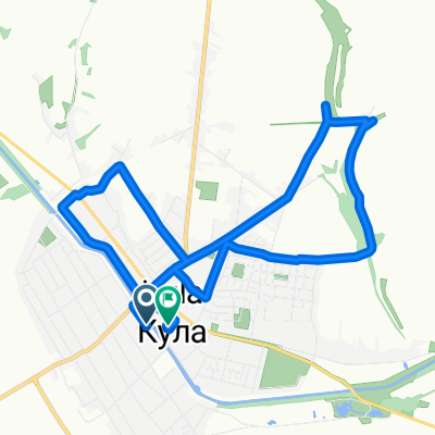
A cycling route starting in Kula, Vojvodina, Serbia.
Overview
About this route
28.07.'12-02.08.'12
I-IV dan: Kula/Vrbas/Apatin-Zagreb 380km IV-V dan: Zagreb VI dan: Zagreb-Osijek (train),Osijek-Kula/Vrbas/Apatin (bike) 290+80km- -:--
- Duration
- 379.5 km
- Distance
- 242 m
- Ascent
- 210 m
- Descent
- ---
- Avg. speed
- ---
- Max. altitude
Route quality
Waytypes & surfaces along the route
Waytypes
Quiet road
38 km
(10 %)
Road
26.6 km
(7 %)
Surfaces
Paved
326.4 km
(86 %)
Unpaved
11.4 km
(3 %)
Asphalt
322.6 km
(85 %)
Ground
7.6 km
(2 %)
Continue with Bikemap
Use, edit, or download this cycling route
You would like to ride Zagreb or customize it for your own trip? Here is what you can do with this Bikemap route:
Free features
- Save this route as favorite or in collections
- Copy & plan your own version of this route
- Split it into stages to create a multi-day tour
- Sync your route with Garmin or Wahoo
Premium features
Free trial for 3 days, or one-time payment. More about Bikemap Premium.
- Navigate this route on iOS & Android
- Export a GPX / KML file of this route
- Create your custom printout (try it for free)
- Download this route for offline navigation
Discover more Premium features.
Get Bikemap PremiumFrom our community
Other popular routes starting in Kula
 Ulica Svetozara Markovića 4/B, Kula to Ulica Svetozara Markovića 6, Kula
- Distance
- 20.2 km
- Ascent
- 119 m
- Descent
- 126 m
- Location
- Kula, Vojvodina, Serbia
 Sporty route
- Distance
- 74.8 km
- Ascent
- 436 m
- Descent
- 488 m
- Location
- Kula, Vojvodina, Serbia
 Kerékpározás
- Distance
- 2.5 km
- Ascent
- 0 m
- Descent
- 0 m
- Location
- Kula, Vojvodina, Serbia
 Ulica Svetozara Markovića 6, Kula to Ulica Svetozara Markovića 4/B, Kula
- Distance
- 18.3 km
- Ascent
- 6 m
- Descent
- 12 m
- Location
- Kula, Vojvodina, Serbia
 Ulica Ive Lole Ribara 37, Kula to Ulica Svetozara Markovića 6, Kula
- Distance
- 12.2 km
- Ascent
- 37 m
- Descent
- 36 m
- Location
- Kula, Vojvodina, Serbia
 Narodnog fronta 54, Ruski Krstur to Moše Pijade 46, Crvenka
- Distance
- 12.3 km
- Ascent
- 7 m
- Descent
- 3 m
- Location
- Kula, Vojvodina, Serbia
 rusanda
- Distance
- 198.2 km
- Ascent
- 49 m
- Descent
- 52 m
- Location
- Kula, Vojvodina, Serbia
 Zagreb
- Distance
- 379.5 km
- Ascent
- 242 m
- Descent
- 210 m
- Location
- Kula, Vojvodina, Serbia
Open it in the app