

Torino - Foresta Nera
Torino - Foresta Nera: Giorno 7: Wolfisberg - Montbovon
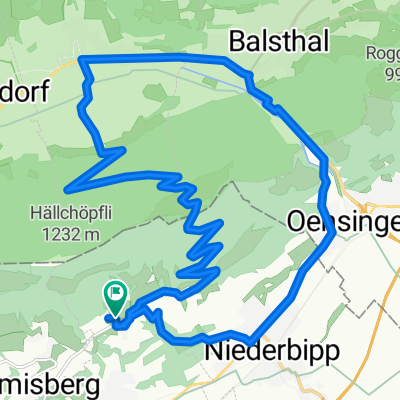
A cycling route starting in Oberbipp, Canton of Bern, Switzerland.
Overview
About this route
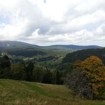
Wolfisberg - Montbovon. 7th stage of Turin - Black forest
- -:--
- Duration
- 121.8 km
- Distance
- 795 m
- Ascent
- 669 m
- Descent
- ---
- Avg. speed
- ---
- Max. altitude

Part of
Torino - Foresta Nera
9 stages
Route quality
Waytypes & surfaces along the route
Waytypes
Quiet road
8.5 km
(7 %)
Road
6.1 km
(5 %)
Surfaces
Paved
80.4 km
(66 %)
Unpaved
3.7 km
(3 %)
Asphalt
78 km
(64 %)
Paved (undefined)
2.4 km
(2 %)
Continue with Bikemap
Use, edit, or download this cycling route
You would like to ride Torino - Foresta Nera: Giorno 7: Wolfisberg - Montbovon or customize it for your own trip? Here is what you can do with this Bikemap route:
Free features
- Save this route as favorite or in collections
- Copy & plan your own version of this route
- Split it into stages to create a multi-day tour
- Sync your route with Garmin or Wahoo
Premium features
Free trial for 3 days, or one-time payment. More about Bikemap Premium.
- Navigate this route on iOS & Android
- Export a GPX / KML file of this route
- Create your custom printout (try it for free)
- Download this route for offline navigation
Discover more Premium features.
Get Bikemap PremiumFrom our community
Other popular routes starting in Oberbipp
 Hasenweg 2, Oberbipp nach Oeschstrasse 5, Subingen
- Distance
- 9.9 km
- Ascent
- 50 m
- Descent
- 121 m
- Location
- Oberbipp, Canton of Bern, Switzerland
 Wolfisberg-Balsthal-Niederbipp-Wolfisberg
- Distance
- 24.5 km
- Ascent
- 684 m
- Descent
- 684 m
- Location
- Oberbipp, Canton of Bern, Switzerland
 Tulpenweg 3, Oberbipp nach Seestrasse 2, Thun
- Distance
- 81 km
- Ascent
- 740 m
- Descent
- 657 m
- Location
- Oberbipp, Canton of Bern, Switzerland
 Sägetweg 18, Oberbipp nach Hauptstrasse 47–49, Solothurn
- Distance
- 20.4 km
- Ascent
- 144 m
- Descent
- 196 m
- Location
- Oberbipp, Canton of Bern, Switzerland
 Oberbipp-Bätlerchuchi
- Distance
- 8.8 km
- Ascent
- 583 m
- Descent
- 42 m
- Location
- Oberbipp, Canton of Bern, Switzerland
 Kirchgasse 1B, Oberbipp nach Wasen im Emmental
- Distance
- 40.4 km
- Ascent
- 715 m
- Descent
- 397 m
- Location
- Oberbipp, Canton of Bern, Switzerland
 Steingasse 28, Oberbipp nach Hauptgasse 66, Solothurn
- Distance
- 12.1 km
- Ascent
- 72 m
- Descent
- 113 m
- Location
- Oberbipp, Canton of Bern, Switzerland
 Aarerunde
- Distance
- 30.3 km
- Ascent
- 206 m
- Descent
- 203 m
- Location
- Oberbipp, Canton of Bern, Switzerland
Open it in the app