

majaelrayo-riaza
A cycling route starting in Majaelrayo, Castille-La Mancha, Spain.
Overview
About this route
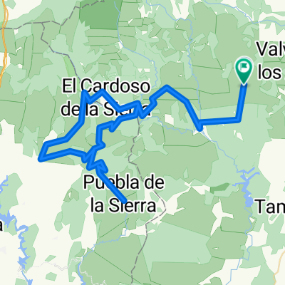
Majaelrayo-Riaza route through the La Quesera pass
- -:--
- Duration
- 40.3 km
- Distance
- 940 m
- Ascent
- 887 m
- Descent
- ---
- Avg. speed
- ---
- Max. altitude

Route quality
Waytypes & surfaces along the route
Waytypes
Road
39.5 km
(98 %)
Quiet road
0.4 km
(1 %)
Track
0.4 km
(1 %)
Continue with Bikemap
Use, edit, or download this cycling route
You would like to ride majaelrayo-riaza or customize it for your own trip? Here is what you can do with this Bikemap route:
Free features
- Save this route as favorite or in collections
- Copy & plan your own version of this route
- Sync your route with Garmin or Wahoo
Premium features
Free trial for 3 days, or one-time payment. More about Bikemap Premium.
- Navigate this route on iOS & Android
- Export a GPX / KML file of this route
- Create your custom printout (try it for free)
- Download this route for offline navigation
Discover more Premium features.
Get Bikemap PremiumFrom our community
Other popular routes starting in Majaelrayo
 Vuelta Sierra Norte de Guadalajara
- Distance
- 102.7 km
- Ascent
- 2,034 m
- Descent
- 2,045 m
- Location
- Majaelrayo, Castille-La Mancha, Spain
 LA QUESERA, por Majaelrayo
- Distance
- 10.3 km
- Ascent
- 575 m
- Descent
- 72 m
- Location
- Majaelrayo, Castille-La Mancha, Spain
 Vuelta a Peñalba
- Distance
- 50.5 km
- Ascent
- 978 m
- Descent
- 972 m
- Location
- Majaelrayo, Castille-La Mancha, Spain
 Majaelrayo-Cantalojas y vuelta
- Distance
- 46.1 km
- Ascent
- 1,137 m
- Descent
- 1,137 m
- Location
- Majaelrayo, Castille-La Mancha, Spain
 Etapa 2: Del refugio de Hijasalvas al molino de la Vereda — Los pueblos negros de Guadalajara - Etapa 2: Del refugio de Hijasalvas al molino de la Vereda
- Distance
- 57.9 km
- Ascent
- 962 m
- Descent
- 1,322 m
- Location
- Majaelrayo, Castille-La Mancha, Spain
 ABRIL 2021
- Distance
- 93.3 km
- Ascent
- 1,557 m
- Descent
- 1,565 m
- Location
- Majaelrayo, Castille-La Mancha, Spain
 La Quesera
- Distance
- 28.1 km
- Ascent
- 912 m
- Descent
- 369 m
- Location
- Majaelrayo, Castille-La Mancha, Spain
 Majaelrayo circular
- Distance
- 105.4 km
- Ascent
- 1,610 m
- Descent
- 1,608 m
- Location
- Majaelrayo, Castille-La Mancha, Spain
Open it in the app