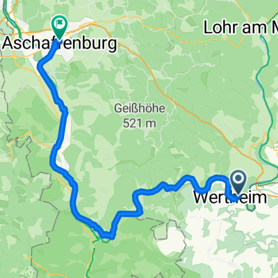
Mainradtour 2013 Siebte Etappe
A cycling route starting in Kreuzwertheim, Bavaria, Germany.
Overview
About this route
Mainradtour 2013 Seventh stage from Kreutwertheim to Wörth.
Eighth stage: http://www.bikemap.net/de/route/2314085-mainradtour-2013-achte-etappe/- -:--
- Duration
- 50.9 km
- Distance
- 255 m
- Ascent
- 290 m
- Descent
- ---
- Avg. speed
- ---
- Max. altitude
Route quality
Waytypes & surfaces along the route
Waytypes
Cycleway
12.7 km
(25 %)
Track
12.2 km
(24 %)
Surfaces
Paved
47.9 km
(94 %)
Unpaved
0.5 km
(1 %)
Asphalt
46.8 km
(92 %)
Concrete
1 km
(2 %)
Route highlights
Points of interest along the route
Point of interest after 0 km
Start in Kreutwertheim.
Point of interest after 50.9 km
Ziel 7. Etappe Campingplatz Mainruh.
Continue with Bikemap
Use, edit, or download this cycling route
You would like to ride Mainradtour 2013 Siebte Etappe or customize it for your own trip? Here is what you can do with this Bikemap route:
Free features
- Save this route as favorite or in collections
- Copy & plan your own version of this route
- Sync your route with Garmin or Wahoo
Premium features
Free trial for 3 days, or one-time payment. More about Bikemap Premium.
- Navigate this route on iOS & Android
- Export a GPX / KML file of this route
- Create your custom printout (try it for free)
- Download this route for offline navigation
Discover more Premium features.
Get Bikemap PremiumFrom our community
Other popular routes starting in Kreuzwertheim
- 15.08.01 Kreuzwertheim-Tauberrettersheim
- Distance
- 67.6 km
- Ascent
- 365 m
- Descent
- 280 m
- Location
- Kreuzwertheim, Bavaria, Germany
- Szprycha w romantycznej Frankonii - 15.07.2019 r.
- Distance
- 48.1 km
- Ascent
- 88 m
- Descent
- 100 m
- Location
- Kreuzwertheim, Bavaria, Germany
- Von Urphar nach Mansbach, Hofstadt 8 Übernachten
- Distance
- 169.8 km
- Ascent
- 3,777 m
- Descent
- 3,607 m
- Location
- Kreuzwertheim, Bavaria, Germany
- Wertheim - Aschaffenburg
- Distance
- 76.1 km
- Ascent
- 59 m
- Descent
- 97 m
- Location
- Kreuzwertheim, Bavaria, Germany
- Dem Main entlang
- Distance
- 16.2 km
- Ascent
- 180 m
- Descent
- 182 m
- Location
- Kreuzwertheim, Bavaria, Germany
- Tauber-Main_06
- Distance
- 69.9 km
- Ascent
- 374 m
- Descent
- 377 m
- Location
- Kreuzwertheim, Bavaria, Germany
- Tauber-Main_05
- Distance
- 48.6 km
- Ascent
- 317 m
- Descent
- 317 m
- Location
- Kreuzwertheim, Bavaria, Germany
- Mainrunde
- Distance
- 45.8 km
- Ascent
- 486 m
- Descent
- 486 m
- Location
- Kreuzwertheim, Bavaria, Germany
Open it in the app