SK/Telgárt - PL/Zakopane
A cycling route starting in Dobšiná, Košický kraj, Slovak Republic.
Overview
About this route
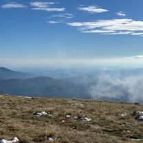
Gute Straßen! Erst durch Niedere Tatra, dann durch Hohe Tatra, beide Regionen sind landschaftlich interessant. Sehr Rücksicht auf Rennradfahrer nehmen die Slowakischen Autofahrer, was man von denen in Polen weniger sagen kann!
- -:--
- Duration
- 98.8 km
- Distance
- 1,877 m
- Ascent
- 1,820 m
- Descent
- ---
- Avg. speed
- 1,126 m
- Avg. speed
Route quality
Waytypes & surfaces along the route
Waytypes
Busy road
57.1 km
(58 %)
Road
35.6 km
(36 %)
Surfaces
Paved
88.1 km
(89 %)
Unpaved
3.3 km
(3 %)
Asphalt
88.1 km
(89 %)
Gravel
3 km
(3 %)
Continue with Bikemap
Use, edit, or download this cycling route
You would like to ride SK/Telgárt - PL/Zakopane or customize it for your own trip? Here is what you can do with this Bikemap route:
Free features
- Save this route as favorite or in collections
- Copy & plan your own version of this route
- Sync your route with Garmin or Wahoo
Premium features
Free trial for 3 days, or one-time payment. More about Bikemap Premium.
- Navigate this route on iOS & Android
- Export a GPX / KML file of this route
- Create your custom printout (try it for free)
- Download this route for offline navigation
Discover more Premium features.
Get Bikemap PremiumFrom our community
Other popular routes starting in Dobšiná
- Dedinky-B.Vody-SNV- Markušovce -Hnilčík
- Distance
- 66.2 km
- Ascent
- 1,721 m
- Descent
- 1,722 m
- Location
- Dobšiná, Košický kraj, Slovak Republic
- Dedinky- Dobš.Maša- Strat. Píla- Geravy- Biele Vody
- Distance
- 26.1 km
- Ascent
- 913 m
- Descent
- 913 m
- Location
- Dobšiná, Košický kraj, Slovak Republic
- Dedinky - Mlynky - Hnilec
- Distance
- 12.5 km
- Ascent
- 86 m
- Descent
- 219 m
- Location
- Dobšiná, Košický kraj, Slovak Republic
- Dedinky-Voniarky- Dobš.j.- s Kopanec- Vernár
- Distance
- 27.7 km
- Ascent
- 1,482 m
- Descent
- 1,495 m
- Location
- Dobšiná, Košický kraj, Slovak Republic
- Dedinky- Strat.Píla- Glac- M. Poľana- Kláštorisko
- Distance
- 28.5 km
- Ascent
- 1,340 m
- Descent
- 1,365 m
- Location
- Dobšiná, Košický kraj, Slovak Republic
- Šumiac, Kráľová Hoľa, Bartková,Pohorelá Šumiac
- Distance
- 39.1 km
- Ascent
- 1,338 m
- Descent
- 1,337 m
- Location
- Dobšiná, Košický kraj, Slovak Republic
- Dedinky- B.Vody- Flajšer- Koš. Briežok- SNV
- Distance
- 27.9 km
- Ascent
- 792 m
- Descent
- 1,116 m
- Location
- Dobšiná, Košický kraj, Slovak Republic
- Dedinky-Flajšer-Koš. Briežok- SNV- Teplička- s.Grajnár
- Distance
- 62.5 km
- Ascent
- 1,882 m
- Descent
- 1,882 m
- Location
- Dobšiná, Košický kraj, Slovak Republic
Open it in the app