
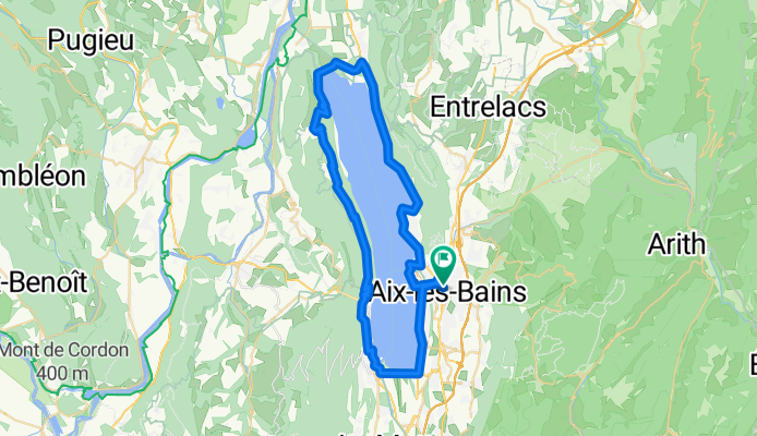
Tour du Lac d'Aix les Bains
A cycling route starting in Aix-les-Bains, Auvergne-Rhône-Alpes, France.
Overview
About this route
Tour of the Lake in an anticlockwise direction
- -:--
- Duration
- 55 km
- Distance
- 649 m
- Ascent
- 649 m
- Descent
- ---
- Avg. speed
- ---
- Max. altitude
Route quality
Waytypes & surfaces along the route
Waytypes
Road
2.7 km
(5 %)
Cycleway
1.6 km
(3 %)
Surfaces
Paved
25.3 km
(46 %)
Asphalt
25.3 km
(46 %)
Undefined
29.7 km
(54 %)
Continue with Bikemap
Use, edit, or download this cycling route
You would like to ride Tour du Lac d'Aix les Bains or customize it for your own trip? Here is what you can do with this Bikemap route:
Free features
- Save this route as favorite or in collections
- Copy & plan your own version of this route
- Sync your route with Garmin or Wahoo
Premium features
Free trial for 3 days, or one-time payment. More about Bikemap Premium.
- Navigate this route on iOS & Android
- Export a GPX / KML file of this route
- Create your custom printout (try it for free)
- Download this route for offline navigation
Discover more Premium features.
Get Bikemap PremiumFrom our community
Other popular routes starting in Aix-les-Bains
 3 - Aux-Lex-Bains to Talloires - Proposed Route
- Distance
- 76.4 km
- Ascent
- 1,243 m
- Descent
- 1,039 m
- Location
- Aix-les-Bains, Auvergne-Rhône-Alpes, France
 De Rue du Maroc 85, Aix-les-Bains à Chemin la Tessonnière d'en Bas 117, La Motte-Servolex
- Distance
- 14.3 km
- Ascent
- 154 m
- Descent
- 120 m
- Location
- Aix-les-Bains, Auvergne-Rhône-Alpes, France
 droga z Aix-les-Bains do Grenoble
- Distance
- 78.6 km
- Ascent
- 399 m
- Descent
- 429 m
- Location
- Aix-les-Bains, Auvergne-Rhône-Alpes, France
 Pyenees to the Alps day 6 a
- Distance
- 85.6 km
- Ascent
- 690 m
- Descent
- 564 m
- Location
- Aix-les-Bains, Auvergne-Rhône-Alpes, France
 Aix-les-Bains Mont Revard
- Distance
- 20.4 km
- Ascent
- 1,320 m
- Descent
- 133 m
- Location
- Aix-les-Bains, Auvergne-Rhône-Alpes, France
 3 - Aux-Lex-Bains to Talloires - Backup 2
- Distance
- 66.7 km
- Ascent
- 1,086 m
- Descent
- 606 m
- Location
- Aix-les-Bains, Auvergne-Rhône-Alpes, France
 Aix Les Bains
- Distance
- 54.3 km
- Ascent
- 881 m
- Descent
- 827 m
- Location
- Aix-les-Bains, Auvergne-Rhône-Alpes, France
 Untitled route
- Distance
- 75.1 km
- Ascent
- 369 m
- Descent
- 294 m
- Location
- Aix-les-Bains, Auvergne-Rhône-Alpes, France
Open it in the app