![20.04.10 Weimar-Köttendorf-Oettern-Kötsch-Volleroda-Weimar [Bilder]](/_next/static/media/contour-lines-light-small.cafd5e5d.avif)
![20.04.10 Weimar-Köttendorf-Oettern-Kötsch-Volleroda-Weimar [Bilder]](https://media.bikemap.net/routes/2314118/staticmaps/in_318d8495-8317-4d07-8511-3b063e2a8e03_694x400_bikemap-2021-3D-static.png)
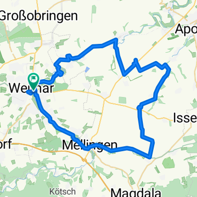
20.04.10 Weimar-Köttendorf-Oettern-Kötsch-Volleroda-Weimar [Bilder]
A cycling route starting in Weimar, Thuringia, Germany.
Overview
About this route
Very little asphalt included. Many challenging climbs and fast descents.
- -:--
- Duration
- 30.6 km
- Distance
- 570 m
- Ascent
- 569 m
- Descent
- ---
- Avg. speed
- ---
- Max. altitude
Route quality
Waytypes & surfaces along the route
Waytypes
Track
19 km
(62 %)
Path
4.3 km
(14 %)
Surfaces
Paved
7 km
(23 %)
Unpaved
20.8 km
(68 %)
Gravel
8.6 km
(28 %)
Asphalt
6.4 km
(21 %)
Route highlights
Points of interest along the route
![Highlight 1 along the Bikemap route "20.04.10 Weimar-Köttendorf-Oettern-Kötsch-Volleroda-Weimar [Bilder]"](https://media.bikemap.net/routes/2314118/pois/067f5028-6ad5-4122-b2fd-48b0f7ec8654.jpeg "Highlight 1 along the Bikemap route \"20.04.10 Weimar-Köttendorf-Oettern-Kötsch-Volleroda-Weimar [Bilder]\"")
Point of interest after 9.4 km
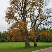
Blick entgegen der Fahrtrichtung. Ab hier ist Uphill angesagt, und das nicht zu knapp!
![Highlight 2 along the Bikemap route "20.04.10 Weimar-Köttendorf-Oettern-Kötsch-Volleroda-Weimar [Bilder]"](https://media.bikemap.net/routes/2314118/pois/d69f4ea5-d9fd-4177-b67f-c16dca2488b8.jpeg "Highlight 2 along the Bikemap route \"20.04.10 Weimar-Köttendorf-Oettern-Kötsch-Volleroda-Weimar [Bilder]\"")
Point of interest after 12.2 km
Casparibank
![Highlight 3 along the Bikemap route "20.04.10 Weimar-Köttendorf-Oettern-Kötsch-Volleroda-Weimar [Bilder]"](https://media.bikemap.net/routes/2314118/pois/4a4aa094-66f8-4a99-ab43-5d3304d348f5.jpeg "Highlight 3 along the Bikemap route \"20.04.10 Weimar-Köttendorf-Oettern-Kötsch-Volleroda-Weimar [Bilder]\"")
Point of interest after 14.1 km
Jetzt geht´s gleich runter. Helmpflicht ;-)
![Highlight 4 along the Bikemap route "20.04.10 Weimar-Köttendorf-Oettern-Kötsch-Volleroda-Weimar [Bilder]"](https://media.bikemap.net/routes/2314118/pois/53b1d6fc-9349-491c-98e8-26b081352c1b.jpeg "Highlight 4 along the Bikemap route \"20.04.10 Weimar-Köttendorf-Oettern-Kötsch-Volleroda-Weimar [Bilder]\"")
Point of interest after 16.8 km
Ich hab den Anstieg nicht ganz geschafft.
![Highlight 5 along the Bikemap route "20.04.10 Weimar-Köttendorf-Oettern-Kötsch-Volleroda-Weimar [Bilder]"](https://media.bikemap.net/routes/2314118/pois/c97548bd-2af0-4711-a889-07fcb6b73b13.jpeg "Highlight 5 along the Bikemap route \"20.04.10 Weimar-Köttendorf-Oettern-Kötsch-Volleroda-Weimar [Bilder]\"")
Point of interest after 16.9 km
![Highlight 6 along the Bikemap route "20.04.10 Weimar-Köttendorf-Oettern-Kötsch-Volleroda-Weimar [Bilder]"](https://media.bikemap.net/routes/2314118/pois/5465b5be-0f69-4ba2-bd89-679b8e12569f.jpeg "Highlight 6 along the Bikemap route \"20.04.10 Weimar-Köttendorf-Oettern-Kötsch-Volleroda-Weimar [Bilder]\"")
Point of interest after 18.7 km
![Highlight 7 along the Bikemap route "20.04.10 Weimar-Köttendorf-Oettern-Kötsch-Volleroda-Weimar [Bilder]"](https://media.bikemap.net/routes/2314118/pois/0813c448-08bb-48ed-ae9a-fbf8bca29e50.jpeg "Highlight 7 along the Bikemap route \"20.04.10 Weimar-Köttendorf-Oettern-Kötsch-Volleroda-Weimar [Bilder]\"")
Point of interest after 18.9 km
Wer hier keine Pause macht ist selbst Schuld.
![Highlight 8 along the Bikemap route "20.04.10 Weimar-Köttendorf-Oettern-Kötsch-Volleroda-Weimar [Bilder]"](https://media.bikemap.net/routes/2314118/pois/265b97ed-a64d-47a8-a1a2-6f6f1a358029.jpeg "Highlight 8 along the Bikemap route \"20.04.10 Weimar-Köttendorf-Oettern-Kötsch-Volleroda-Weimar [Bilder]\"")
Point of interest after 20.2 km
![Highlight 9 along the Bikemap route "20.04.10 Weimar-Köttendorf-Oettern-Kötsch-Volleroda-Weimar [Bilder]"](https://media.bikemap.net/routes/2314118/pois/0ae8dedf-6bc7-4aaf-b917-d1600b6fa844.jpeg "Highlight 9 along the Bikemap route \"20.04.10 Weimar-Köttendorf-Oettern-Kötsch-Volleroda-Weimar [Bilder]\"")
Point of interest after 20.6 km
![Highlight 10 along the Bikemap route "20.04.10 Weimar-Köttendorf-Oettern-Kötsch-Volleroda-Weimar [Bilder]"](https://media.bikemap.net/routes/2314118/pois/c851a99b-56f6-42fd-b742-342191b5d2fc.jpeg "Highlight 10 along the Bikemap route \"20.04.10 Weimar-Köttendorf-Oettern-Kötsch-Volleroda-Weimar [Bilder]\"")
Point of interest after 21.2 km
Blick zurück auf Buchfart.
![Highlight 11 along the Bikemap route "20.04.10 Weimar-Köttendorf-Oettern-Kötsch-Volleroda-Weimar [Bilder]"](https://media.bikemap.net/routes/2314118/pois/daaeb1bb-cf68-45b0-9f05-075d28e628c0.jpeg "Highlight 11 along the Bikemap route \"20.04.10 Weimar-Köttendorf-Oettern-Kötsch-Volleroda-Weimar [Bilder]\"")
Point of interest after 21.3 km
Hier habe ich die Route ein wenig verplant. Diese Tragepassage war nicht vorgesehen.
![Highlight 12 along the Bikemap route "20.04.10 Weimar-Köttendorf-Oettern-Kötsch-Volleroda-Weimar [Bilder]"](https://media.bikemap.net/routes/2314118/pois/ab852a22-6723-4f90-b853-d462d732fa11.jpeg "Highlight 12 along the Bikemap route \"20.04.10 Weimar-Köttendorf-Oettern-Kötsch-Volleroda-Weimar [Bilder]\"")
Point of interest after 21.6 km
Die Balsamine. Schönes Pause-Plätzchen!
![Highlight 13 along the Bikemap route "20.04.10 Weimar-Köttendorf-Oettern-Kötsch-Volleroda-Weimar [Bilder]"](https://media.bikemap.net/routes/2314118/pois/db696bf4-bf85-4416-8223-0bb38ec0110e.jpeg "Highlight 13 along the Bikemap route \"20.04.10 Weimar-Köttendorf-Oettern-Kötsch-Volleroda-Weimar [Bilder]\"")
Point of interest after 24.9 km
![Highlight 14 along the Bikemap route "20.04.10 Weimar-Köttendorf-Oettern-Kötsch-Volleroda-Weimar [Bilder]"](https://media.bikemap.net/routes/2314118/pois/ab76c922-b2e6-4ee2-8937-40b5b7763e8b.jpeg "Highlight 14 along the Bikemap route \"20.04.10 Weimar-Köttendorf-Oettern-Kötsch-Volleroda-Weimar [Bilder]\"")
Point of interest after 25.4 km
Jetzt kommt noch mal ein toller Singeltrail kurz vor Einfahrt nach Weimar.
![Highlight 15 along the Bikemap route "20.04.10 Weimar-Köttendorf-Oettern-Kötsch-Volleroda-Weimar [Bilder]"](https://media.bikemap.net/routes/2314118/pois/b78f511d-cca2-43ef-9131-be399220567e.jpeg "Highlight 15 along the Bikemap route \"20.04.10 Weimar-Köttendorf-Oettern-Kötsch-Volleroda-Weimar [Bilder]\"")
Point of interest after 25.8 km
Schöner Blick auf Weimar.
![Highlight 16 along the Bikemap route "20.04.10 Weimar-Köttendorf-Oettern-Kötsch-Volleroda-Weimar [Bilder]"](https://media.bikemap.net/routes/2314118/pois/6caee320-3838-436e-bb61-6f2b7aec19f3.jpeg "Highlight 16 along the Bikemap route \"20.04.10 Weimar-Köttendorf-Oettern-Kötsch-Volleroda-Weimar [Bilder]\"")
Point of interest after 27.3 km
Für alle Fully-Fahrer stellt sich jetzt heraus ob das Fahrwerk gut eingestellt ist :-)
Continue with Bikemap
Use, edit, or download this cycling route
You would like to ride 20.04.10 Weimar-Köttendorf-Oettern-Kötsch-Volleroda-Weimar [Bilder] or customize it for your own trip? Here is what you can do with this Bikemap route:
Free features
- Save this route as favorite or in collections
- Copy & plan your own version of this route
- Sync your route with Garmin or Wahoo
Premium features
Free trial for 3 days, or one-time payment. More about Bikemap Premium.
- Navigate this route on iOS & Android
- Export a GPX / KML file of this route
- Create your custom printout (try it for free)
- Download this route for offline navigation
Discover more Premium features.
Get Bikemap PremiumFrom our community
Other popular routes starting in Weimar
 Von Weimar bis Leipzig
- Distance
- 110.8 km
- Ascent
- 630 m
- Descent
- 744 m
- Location
- Weimar, Thuringia, Germany
![10.04.10 Ilmtal-Salle-Radwanderweg zurück über Jena [Bilder]](https://media.bikemap.net/routes/443141/staticmaps/in_0131ad86-0f8d-40e3-b0dd-ec2b4f109e5f_400x400_bikemap-2021-3D-static.png) 10.04.10 Ilmtal-Salle-Radwanderweg zurück über Jena [Bilder]
10.04.10 Ilmtal-Salle-Radwanderweg zurück über Jena [Bilder]- Distance
- 93.9 km
- Ascent
- 608 m
- Descent
- 590 m
- Location
- Weimar, Thuringia, Germany
![08.06.10 Weimar-Bad Berka-Weimar [Bilder]](https://media.bikemap.net/routes/532257/staticmaps/in_f392eacb-2c73-4e2c-ba54-64c1172ea5bf_400x400_bikemap-2021-3D-static.png) 08.06.10 Weimar-Bad Berka-Weimar [Bilder]
08.06.10 Weimar-Bad Berka-Weimar [Bilder]- Distance
- 32 km
- Ascent
- 470 m
- Descent
- 472 m
- Location
- Weimar, Thuringia, Germany
 Leibnizallee 1A nach Corona-Schröter-Weg
- Distance
- 7.3 km
- Ascent
- 81 m
- Descent
- 89 m
- Location
- Weimar, Thuringia, Germany
 Friedensradfahrt 2009 Paris - Moskau 15. Etappe Weimar - Bad Sulza am 20. Juli 2009
- Distance
- 29.1 km
- Ascent
- 192 m
- Descent
- 260 m
- Location
- Weimar, Thuringia, Germany
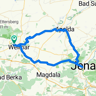 Pętla Weimar-Apolda-Jena-Weimar
- Distance
- 59.2 km
- Ascent
- 570 m
- Descent
- 575 m
- Location
- Weimar, Thuringia, Germany
 Rundtour um Weimar
- Distance
- 41.2 km
- Ascent
- 241 m
- Descent
- 249 m
- Location
- Weimar, Thuringia, Germany
 Himmelfahrtausfahrt (Weimarer Löwen) 2012-05-17
- Distance
- 77.7 km
- Ascent
- 435 m
- Descent
- 435 m
- Location
- Weimar, Thuringia, Germany
Open it in the app