

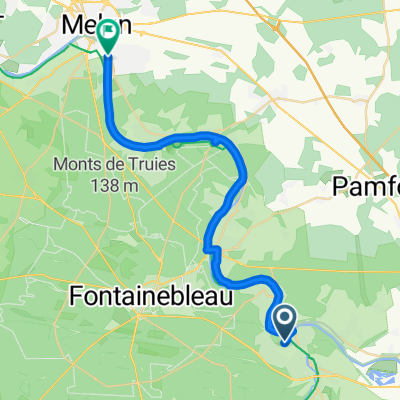
La forêt de Fontainebleau d'est en ouest
A cycling route starting in Veneux-les-Sablons, Île-de-France Region, France.
Overview
About this route
De Moret-Veneux-les-Sablons (Transilien R) à Buno-Gironville (RER D). Attention seulement un train par heure le dimanche sur cette portion du RER D.
Quelques rares passages difficiles (sables, rocher) notament sur le TMF à l'ouest de la N7. Un gros passage sableux impossible dans le massif des 3 pignons, évitable en passant plus au sud près d'Achères.- -:--
- Duration
- 36.8 km
- Distance
- 202 m
- Ascent
- 204 m
- Descent
- ---
- Avg. speed
- ---
- Avg. speed

Route quality
Waytypes & surfaces along the route
Waytypes
Track
19.6 km
(53 %)
Road
9.9 km
(27 %)
Surfaces
Paved
15.7 km
(43 %)
Unpaved
4.4 km
(12 %)
Asphalt
15.7 km
(43 %)
Gravel
2.6 km
(7 %)
Continue with Bikemap
Use, edit, or download this cycling route
You would like to ride La forêt de Fontainebleau d'est en ouest or customize it for your own trip? Here is what you can do with this Bikemap route:
Free features
- Save this route as favorite or in collections
- Copy & plan your own version of this route
- Sync your route with Garmin or Wahoo
Premium features
Free trial for 3 days, or one-time payment. More about Bikemap Premium.
- Navigate this route on iOS & Android
- Export a GPX / KML file of this route
- Create your custom printout (try it for free)
- Download this route for offline navigation
Discover more Premium features.
Get Bikemap PremiumFrom our community
Other popular routes starting in Veneux-les-Sablons
 VRP12_Moret-sur-Loing - Melun_29km
- Distance
- 29.1 km
- Ascent
- 72 m
- Descent
- 81 m
- Location
- Veneux-les-Sablons, Île-de-France Region, France
 Aadorf - Paris 10. Tag Veneux-les-Sablons - PARIS
- Distance
- 103.9 km
- Ascent
- 322 m
- Descent
- 346 m
- Location
- Veneux-les-Sablons, Île-de-France Region, France
 Avon - Mulhouse
- Distance
- 658 km
- Ascent
- 2,755 m
- Descent
- 2,587 m
- Location
- Veneux-les-Sablons, Île-de-France Region, France
 La forêt de Fontainebleau d'est en ouest
- Distance
- 36.8 km
- Ascent
- 202 m
- Descent
- 204 m
- Location
- Veneux-les-Sablons, Île-de-France Region, France
 test
test- Distance
- 41.7 km
- Ascent
- 205 m
- Descent
- 205 m
- Location
- Veneux-les-Sablons, Île-de-France Region, France
 Vallée du Loing, du Lunain et de l'Orvanne (Seine et Marne)
- Distance
- 78.7 km
- Ascent
- 245 m
- Descent
- 245 m
- Location
- Veneux-les-Sablons, Île-de-France Region, France
 Short bike tour from Veneux-les-Sablons to Moret-sur-Loing
- Distance
- 2.4 km
- Ascent
- 8 m
- Descent
- 9 m
- Location
- Veneux-les-Sablons, Île-de-France Region, France
 Moret Nemours
- Distance
- 42.2 km
- Ascent
- 0 m
- Descent
- 24 m
- Location
- Veneux-les-Sablons, Île-de-France Region, France
Open it in the app