

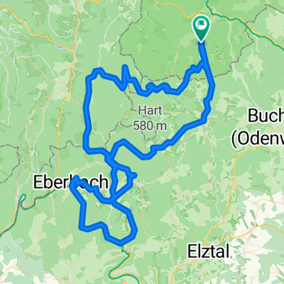
Kirchzell - Mudau - Gaimühle - Kirchzell
A cycling route starting in Kirchzell, Bavaria, Germany.
Overview
About this route
- Kirchzell (Buch)
- Preunschen
- Mudau
- Raisenbach
- Gaimühle
- Kailbach
- Ernsttal
- Preunschen
- Kirchzell (Buch)
- -:--
- Duration
- 59.4 km
- Distance
- 1,317 m
- Ascent
- 1,124 m
- Descent
- ---
- Avg. speed
- 549 m
- Max. altitude

Route quality
Waytypes & surfaces along the route
Waytypes
Road
24.3 km
(41 %)
Track
7.1 km
(12 %)
Surfaces
Paved
48.7 km
(82 %)
Unpaved
4.2 km
(7 %)
Asphalt
46.9 km
(79 %)
Gravel
3 km
(5 %)
Continue with Bikemap
Use, edit, or download this cycling route
You would like to ride Kirchzell - Mudau - Gaimühle - Kirchzell or customize it for your own trip? Here is what you can do with this Bikemap route:
Free features
- Save this route as favorite or in collections
- Copy & plan your own version of this route
- Sync your route with Garmin or Wahoo
Premium features
Free trial for 3 days, or one-time payment. More about Bikemap Premium.
- Navigate this route on iOS & Android
- Export a GPX / KML file of this route
- Create your custom printout (try it for free)
- Download this route for offline navigation
Discover more Premium features.
Get Bikemap PremiumFrom our community
Other popular routes starting in Kirchzell
 Katzenbuckel - Sensbachtal
- Distance
- 75.9 km
- Ascent
- 1,466 m
- Descent
- 1,331 m
- Location
- Kirchzell, Bavaria, Germany
 "leichtere" Neckarrunde
- Distance
- 82.6 km
- Ascent
- 842 m
- Descent
- 845 m
- Location
- Kirchzell, Bavaria, Germany
 Rundkurs Miltenberg
- Distance
- 84.1 km
- Ascent
- 1,146 m
- Descent
- 1,187 m
- Location
- Kirchzell, Bavaria, Germany
 tour 180417 amorbach miltenberg trailtour odenwald
- Distance
- 54.2 km
- Ascent
- 1,118 m
- Descent
- 1,118 m
- Location
- Kirchzell, Bavaria, Germany
 Kirchzell - Mudau - Gaimühle - Kirchzell
- Distance
- 59.4 km
- Ascent
- 1,317 m
- Descent
- 1,124 m
- Location
- Kirchzell, Bavaria, Germany
 Kirchzell - Breitenbuch - Würzberg - Wörth - Klingenberg - Mönchberg - Collenberg - Mil - Weilbach - Buch
- Distance
- 85.6 km
- Ascent
- 886 m
- Descent
- 886 m
- Location
- Kirchzell, Bavaria, Germany
 Buch über Schwabenstein und Gleis 1 nach Buch
- Distance
- 23.1 km
- Ascent
- 400 m
- Descent
- 457 m
- Location
- Kirchzell, Bavaria, Germany
 Kirchzell - Neckar - Kirchzell
- Distance
- 112.2 km
- Ascent
- 2,455 m
- Descent
- 2,278 m
- Location
- Kirchzell, Bavaria, Germany
Open it in the app