
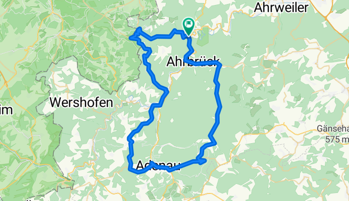
Ahrrunde zur Hohen Acht
A cycling route starting in Altenahr, Rhineland-Palatinate, Germany.
Overview
About this route
Nice during the week as there is little motorcycle traffic in the Kesslinger Valley
- -:--
- Duration
- 61.5 km
- Distance
- 1,067 m
- Ascent
- 951 m
- Descent
- ---
- Avg. speed
- 626 m
- Max. altitude
Route quality
Waytypes & surfaces along the route
Waytypes
Road
14.1 km
(23 %)
Track
8 km
(13 %)
Surfaces
Paved
42.4 km
(69 %)
Unpaved
6.8 km
(11 %)
Asphalt
42.4 km
(69 %)
Ground
4.3 km
(7 %)
Continue with Bikemap
Use, edit, or download this cycling route
You would like to ride Ahrrunde zur Hohen Acht or customize it for your own trip? Here is what you can do with this Bikemap route:
Free features
- Save this route as favorite or in collections
- Copy & plan your own version of this route
- Sync your route with Garmin or Wahoo
Premium features
Free trial for 3 days, or one-time payment. More about Bikemap Premium.
- Navigate this route on iOS & Android
- Export a GPX / KML file of this route
- Create your custom printout (try it for free)
- Download this route for offline navigation
Discover more Premium features.
Get Bikemap PremiumFrom our community
Other popular routes starting in Altenahr
 Altenahr - Schrock - Steinerberghaus - Teufelsloch
- Distance
- 16.7 km
- Ascent
- 718 m
- Descent
- 719 m
- Location
- Altenahr, Rhineland-Palatinate, Germany
 RRR3 (Mittlere Runde Altenahr)
- Distance
- 71.1 km
- Ascent
- 1,160 m
- Descent
- 1,078 m
- Location
- Altenahr, Rhineland-Palatinate, Germany
 Saturday trail
- Distance
- 13.8 km
- Ascent
- 452 m
- Descent
- 452 m
- Location
- Altenahr, Rhineland-Palatinate, Germany
 Kreuzberg (Ahr) - Ahrweiler - Remagen - Bh.Bad Godesberg
- Distance
- 49.6 km
- Ascent
- 101 m
- Descent
- 206 m
- Location
- Altenahr, Rhineland-Palatinate, Germany
 Altenahr - Mönchengladbach
- Distance
- 103.9 km
- Ascent
- 288 m
- Descent
- 382 m
- Location
- Altenahr, Rhineland-Palatinate, Germany
 Familienradtour in Coronazeiten
- Distance
- 32.6 km
- Ascent
- 331 m
- Descent
- 332 m
- Location
- Altenahr, Rhineland-Palatinate, Germany
 CYCLING THE RHINE: Route 10B(b)
- Distance
- 35.9 km
- Ascent
- 84 m
- Descent
- 195 m
- Location
- Altenahr, Rhineland-Palatinate, Germany
 Testfahrt anl. der Winterwanderung der KfA 2018
- Distance
- 13.7 km
- Ascent
- 393 m
- Descent
- 394 m
- Location
- Altenahr, Rhineland-Palatinate, Germany
Open it in the app