

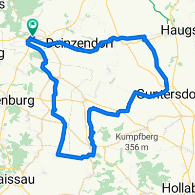
Pulkau - Kamptal - Strassertal
A cycling route starting in Pulkau, Lower Austria, Austria.
Overview
About this route
Pulkau - Horn - Rosenburg - Gars - Zöbing - Strass - Eggendorf - Burgschleinitz - Eggenburg - Pulkau (85km)
- -:--
- Duration
- 85.5 km
- Distance
- 546 m
- Ascent
- 545 m
- Descent
- ---
- Avg. speed
- ---
- Avg. speed
Route quality
Waytypes & surfaces along the route
Waytypes
Busy road
64 km
(75 %)
Road
15 km
(18 %)
Surfaces
Paved
59.9 km
(70 %)
Unpaved
0.9 km
(1 %)
Asphalt
59.5 km
(70 %)
Gravel
0.6 km
(<1 %)
Continue with Bikemap
Use, edit, or download this cycling route
You would like to ride Pulkau - Kamptal - Strassertal or customize it for your own trip? Here is what you can do with this Bikemap route:
Free features
- Save this route as favorite or in collections
- Copy & plan your own version of this route
- Sync your route with Garmin or Wahoo
Premium features
Free trial for 3 days, or one-time payment. More about Bikemap Premium.
- Navigate this route on iOS & Android
- Export a GPX / KML file of this route
- Create your custom printout (try it for free)
- Download this route for offline navigation
Discover more Premium features.
Get Bikemap PremiumFrom our community
Other popular routes starting in Pulkau
 Pulkau - Röschitz - Zellerndorf - Pillersdorf - Pulkau
- Distance
- 37.2 km
- Ascent
- 326 m
- Descent
- 388 m
- Location
- Pulkau, Lower Austria, Austria
 kleiner DAC Weg
- Distance
- 32.5 km
- Ascent
- 279 m
- Descent
- 330 m
- Location
- Pulkau, Lower Austria, Austria
 Pulkau - Sitzendorf - Guntersdorf - Pernersdorf - Pulkau
- Distance
- 56 km
- Ascent
- 519 m
- Descent
- 421 m
- Location
- Pulkau, Lower Austria, Austria
 Pulkau - Sitzendorf - Maissau - Eggenburg - Pulkau
- Distance
- 56.7 km
- Ascent
- 559 m
- Descent
- 612 m
- Location
- Pulkau, Lower Austria, Austria
 Riesling Radroute
- Distance
- 60.9 km
- Ascent
- 539 m
- Descent
- 592 m
- Location
- Pulkau, Lower Austria, Austria
 Pulkau - Kamptal - Strassertal
- Distance
- 85.5 km
- Ascent
- 546 m
- Descent
- 545 m
- Location
- Pulkau, Lower Austria, Austria
 Pulkau - Hardegg
- Distance
- 66.7 km
- Ascent
- 596 m
- Descent
- 596 m
- Location
- Pulkau, Lower Austria, Austria
 Wein- und Kulturradweg Retz-Znaim-Retz
- Distance
- 79.8 km
- Ascent
- 668 m
- Descent
- 717 m
- Location
- Pulkau, Lower Austria, Austria
Open it in the app