

PL/Zakopane - SK/Teplicka nad Váhom
A cycling route starting in Zakopane, Lesser Poland Voivodeship, Poland.
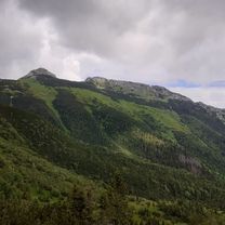
Overview
About this route
Good roads, scenically interesting, with phases of heavy car traffic. Unfortunately interrupted due to heavy rain.
- -:--
- Duration
- 129.8 km
- Distance
- 495 m
- Ascent
- 958 m
- Descent
- ---
- Avg. speed
- ---
- Max. altitude

Continue with Bikemap
Use, edit, or download this cycling route
You would like to ride PL/Zakopane - SK/Teplicka nad Váhom or customize it for your own trip? Here is what you can do with this Bikemap route:
Free features
- Save this route as favorite or in collections
- Copy & plan your own version of this route
- Split it into stages to create a multi-day tour
- Sync your route with Garmin or Wahoo
Premium features
Free trial for 3 days, or one-time payment. More about Bikemap Premium.
- Navigate this route on iOS & Android
- Export a GPX / KML file of this route
- Create your custom printout (try it for free)
- Download this route for offline navigation
Discover more Premium features.
Get Bikemap PremiumFrom our community
Other popular routes starting in Zakopane
 Kellys Enduro - Joy Ride Zako Days 2016
- Distance
- 34.4 km
- Ascent
- 1,019 m
- Descent
- 1,019 m
- Location
- Zakopane, Lesser Poland Voivodeship, Poland
 10.08.18 tour de Zako
- Distance
- 77.1 km
- Ascent
- 2,779 m
- Descent
- 2,761 m
- Location
- Zakopane, Lesser Poland Voivodeship, Poland
 Day 2 Easier option
- Distance
- 15.5 km
- Ascent
- 661 m
- Descent
- 664 m
- Location
- Zakopane, Lesser Poland Voivodeship, Poland
 OSTURNA (przez Gliczarów-nie jak TdP oraz nową drogą z Wyżniego Końca i Zdiarskie sedlo) - 3-10-15
- Distance
- 90 km
- Ascent
- 1,419 m
- Descent
- 1,417 m
- Location
- Zakopane, Lesser Poland Voivodeship, Poland
 Zakopane
- Distance
- 64.8 km
- Ascent
- 968 m
- Descent
- 911 m
- Location
- Zakopane, Lesser Poland Voivodeship, Poland
 Día 3. Zakopane Kezmarok
- Distance
- 70.8 km
- Ascent
- 889 m
- Descent
- 1,114 m
- Location
- Zakopane, Lesser Poland Voivodeship, Poland
 23.7.2018
- Distance
- 55.6 km
- Ascent
- 784 m
- Descent
- 784 m
- Location
- Zakopane, Lesser Poland Voivodeship, Poland
 13.07.20 Kopa Kondracka
- Distance
- 13.1 km
- Ascent
- 967 m
- Descent
- 962 m
- Location
- Zakopane, Lesser Poland Voivodeship, Poland
Open it in the app