

p14 Passo Gavia
A cycling route starting in Ponte di Legno, Lombardy, Italy.
Overview
About this route
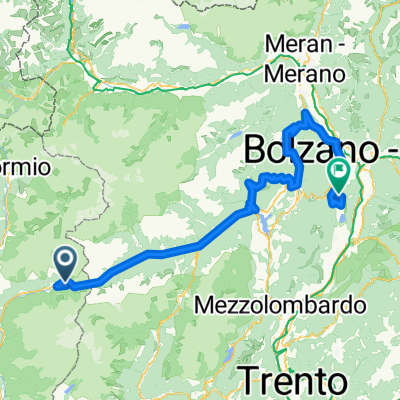
Passo Gavia Pass (2652 m above sea level) I rode on 6.07.2013 from Ponte di Legno to Bormio.
- -:--
- Duration
- 42.9 km
- Distance
- 1,305 m
- Ascent
- 1,454 m
- Descent
- ---
- Avg. speed
- ---
- Max. altitude

Route quality
Waytypes & surfaces along the route
Waytypes
Quiet road
0.9 km
(2 %)
Undefined
42 km
(98 %)
Surfaces
Paved
42.5 km
(99 %)
Asphalt
42.5 km
(99 %)
Undefined
0.4 km
(1 %)
Route highlights
Points of interest along the route

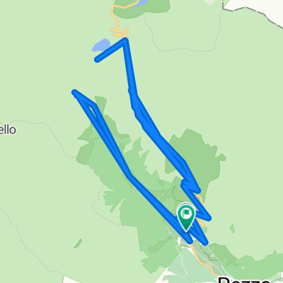
Point of interest after 16.8 km
Passo Gavia (2652 m n.p.m.)
Continue with Bikemap
Use, edit, or download this cycling route
You would like to ride p14 Passo Gavia or customize it for your own trip? Here is what you can do with this Bikemap route:
Free features
- Save this route as favorite or in collections
- Copy & plan your own version of this route
- Sync your route with Garmin or Wahoo
Premium features
Free trial for 3 days, or one-time payment. More about Bikemap Premium.
- Navigate this route on iOS & Android
- Export a GPX / KML file of this route
- Create your custom printout (try it for free)
- Download this route for offline navigation
Discover more Premium features.
Get Bikemap PremiumFrom our community
Other popular routes starting in Ponte di Legno
 Ciclovia dell'Oglio
- Distance
- 274.5 km
- Ascent
- 53 m
- Descent
- 1,912 m
- Location
- Ponte di Legno, Lombardy, Italy
 TOUR-Transalp 2011 - 6. Etappe
- Distance
- 139.9 km
- Ascent
- 2,654 m
- Descent
- 3,497 m
- Location
- Ponte di Legno, Lombardy, Italy
 p14 Passo Gavia
- Distance
- 42.9 km
- Ascent
- 1,305 m
- Descent
- 1,454 m
- Location
- Ponte di Legno, Lombardy, Italy
 Gallo Trail vom Gavia Pass nach Pezzo
- Distance
- 130.8 km
- Ascent
- 6,542 m
- Descent
- 6,545 m
- Location
- Ponte di Legno, Lombardy, Italy
 Ponte di Legno - Madonna di Campilglio
- Distance
- 58 km
- Ascent
- 2,765 m
- Descent
- 2,510 m
- Location
- Ponte di Legno, Lombardy, Italy
 AlpenCross 2017 6. Etappe
- Distance
- 53.8 km
- Ascent
- 1,983 m
- Descent
- 1,693 m
- Location
- Ponte di Legno, Lombardy, Italy
 Ponte di Legno - Aprica - Mortirolo - Ponte di Legno
- Distance
- 101.5 km
- Ascent
- 2,551 m
- Descent
- 2,546 m
- Location
- Ponte di Legno, Lombardy, Italy
 Jeantex Tour Transalp 2007 6. Etappe
- Distance
- 108.6 km
- Ascent
- 2,948 m
- Descent
- 3,658 m
- Location
- Ponte di Legno, Lombardy, Italy
Open it in the app