

BCB. Tres rios; por el Valle de Manzanedo Ebro, Trifón y Nela.
A cycling route starting in Medina de Pomar, Castille and León, Spain.
Overview
About this route
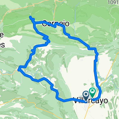
From Burgos take the road to Villarcayo until Incinillas and leave the car there. Take the BU 5741 towards Manzanedo. In the Valley of Manzanedo, before the village of Rioseco, on the right hand side, there are the ruins of the eponymous monastery. You can swim in the Ebro a few kilometers later, going down to the river on the left hand side. At the first crossing you have to take the BU 5746 to the right, towards Soncillo. Under the village of Landraves you can find the gorge of Palancas. The next village, Hoz, is very pretty with the río Trifón flowing through it. Then you have to go uphill; below you can see some huge caves. Go down to Soncillo - there are beautiful views on the way down. In Soncillo you have to take the road towards Espinosa, BU 526. Down there, before Santelices turn right onto the BU 561 which follows the river Nela, one of the prettiest rivers in the province. Enter the village of Puentedey with its wonderful natural arch. The surroundings and the village are very nice and it's a good place to eat. Return to the road towards Villarcayo; there take CL 629 and then the national 232 towards Incinillas.
- -:--
- Duration
- 58.3 km
- Distance
- 528 m
- Ascent
- 497 m
- Descent
- ---
- Avg. speed
- ---
- Max. altitude

Route quality
Waytypes & surfaces along the route
Waytypes
Road
24.5 km
(42 %)
Quiet road
2.3 km
(4 %)
Surfaces
Paved
56 km
(96 %)
Unpaved
0.6 km
(1 %)
Asphalt
56 km
(96 %)
Ground
0.6 km
(1 %)
Undefined
1.7 km
(3 %)
Continue with Bikemap
Use, edit, or download this cycling route
You would like to ride BCB. Tres rios; por el Valle de Manzanedo Ebro, Trifón y Nela. or customize it for your own trip? Here is what you can do with this Bikemap route:
Free features
- Save this route as favorite or in collections
- Copy & plan your own version of this route
- Sync your route with Garmin or Wahoo
Premium features
Free trial for 3 days, or one-time payment. More about Bikemap Premium.
- Navigate this route on iOS & Android
- Export a GPX / KML file of this route
- Create your custom printout (try it for free)
- Download this route for offline navigation
Discover more Premium features.
Get Bikemap PremiumFrom our community
Other popular routes starting in Medina de Pomar
 Puentedey
- Distance
- 43.6 km
- Ascent
- 405 m
- Descent
- 406 m
- Location
- Medina de Pomar, Castille and León, Spain
 OIncinillas
- Distance
- 8.7 km
- Ascent
- 337 m
- Descent
- 398 m
- Location
- Medina de Pomar, Castille and León, Spain
 OndaCero BCB. Bici y baño 3. Puentedey
- Distance
- 43.6 km
- Ascent
- 405 m
- Descent
- 407 m
- Location
- Medina de Pomar, Castille and León, Spain
 CAMINOS BAJO LA TESLA
- Distance
- 33.4 km
- Ascent
- 284 m
- Descent
- 283 m
- Location
- Medina de Pomar, Castille and León, Spain
 BCB. Las Merindades por cuatro rios
- Distance
- 59.4 km
- Ascent
- 812 m
- Descent
- 813 m
- Location
- Medina de Pomar, Castille and León, Spain
 Merindadeak Medinatik 1. eguna
- Distance
- 47.1 km
- Ascent
- 300 m
- Descent
- 296 m
- Location
- Medina de Pomar, Castille and León, Spain
 BCB. 10º Aniversario (2). MAME
- Distance
- 44.7 km
- Ascent
- 626 m
- Descent
- 627 m
- Location
- Medina de Pomar, Castille and León, Spain
 De ?d›˛? a ?d›˛?
- Distance
- 10.7 km
- Ascent
- 102 m
- Descent
- 140 m
- Location
- Medina de Pomar, Castille and León, Spain
Open it in the app