Castro Valley-Reliz Valley-Deer Hill-Wildcat
A cycling route starting in Berkeley, California, United States.
Overview
About this route
Excellent training ride with a warm up descent, fast fun roads and backloaded climbs with steep sections
- -:--
- Duration
- 66.3 km
- Distance
- 954 m
- Ascent
- 952 m
- Descent
- ---
- Avg. speed
- ---
- Max. altitude
Route quality
Waytypes & surfaces along the route
Waytypes
Road
31.8 km
(48 %)
Quiet road
1.3 km
(2 %)
Undefined
33.2 km
(50 %)
Surfaces
Paved
32.5 km
(49 %)
Asphalt
32.5 km
(49 %)
Undefined
33.8 km
(51 %)
Continue with Bikemap
Use, edit, or download this cycling route
You would like to ride Castro Valley-Reliz Valley-Deer Hill-Wildcat or customize it for your own trip? Here is what you can do with this Bikemap route:
Free features
- Save this route as favorite or in collections
- Copy & plan your own version of this route
- Sync your route with Garmin or Wahoo
Premium features
Free trial for 3 days, or one-time payment. More about Bikemap Premium.
- Navigate this route on iOS & Android
- Export a GPX / KML file of this route
- Create your custom printout (try it for free)
- Download this route for offline navigation
Discover more Premium features.
Get Bikemap PremiumFrom our community
Other popular routes starting in Berkeley
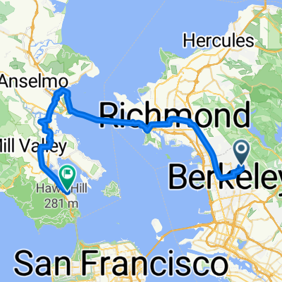
Wildcat Canyon o&b + Briones Park circuit- Distance
- 60.3 km
- Ascent
- 1,429 m
- Descent
- 1,458 m
- Location
- Berkeley, California, United States
NB BART To Inspiration Point- Distance
- 22.7 km
- Ascent
- 425 m
- Descent
- 424 m
- Location
- Berkeley, California, United States
Innersport to 3 Bears (clockwise) and return- Distance
- 78 km
- Ascent
- 1,010 m
- Descent
- 1,010 m
- Location
- Berkeley, California, United States
N Oakland - Tunnel - Pinehurst N-S - Pig Farm - 3 Bears CW - Wildcat - Spruce - N Oakland- Distance
- 81.5 km
- Ascent
- 2,113 m
- Descent
- 2,095 m
- Location
- Berkeley, California, United States
Spruce Wildcat Orinda Toyonal (SWOT)- Distance
- 30.1 km
- Ascent
- 759 m
- Descent
- 759 m
- Location
- Berkeley, California, United States
johanna smooth ride- Distance
- 49.4 km
- Ascent
- 419 m
- Descent
- 632 m
- Location
- Berkeley, California, United States
Three Bears- Distance
- 58.3 km
- Ascent
- 1,476 m
- Descent
- 1,476 m
- Location
- Berkeley, California, United States
small loop- Distance
- 15 km
- Ascent
- 379 m
- Descent
- 379 m
- Location
- Berkeley, California, United States
Open it in the app


