
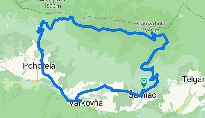
Šumiac, Kráľová Hoľa, Bartková,Pohorelá Šumiac
A cycling route starting in Dobšiná, Košice Region, Slovakia.
Overview
About this route
Challenging mountain trail
- -:--
- Duration
- 39.1 km
- Distance
- 1,338 m
- Ascent
- 1,337 m
- Descent
- ---
- Avg. speed
- ---
- Max. altitude

Route highlights
Points of interest along the route
Point of interest after 11 km
Vrchol
Point of interest after 13.8 km
Stredná Hoľa.
Point of interest after 15.6 km
Orlová 1840
Point of interest after 17.5 km
Bartková 1790
Continue with Bikemap
Use, edit, or download this cycling route
You would like to ride Šumiac, Kráľová Hoľa, Bartková,Pohorelá Šumiac or customize it for your own trip? Here is what you can do with this Bikemap route:
Free features
- Save this route as favorite or in collections
- Copy & plan your own version of this route
- Sync your route with Garmin or Wahoo
Premium features
Free trial for 3 days, or one-time payment. More about Bikemap Premium.
- Navigate this route on iOS & Android
- Export a GPX / KML file of this route
- Create your custom printout (try it for free)
- Download this route for offline navigation
Discover more Premium features.
Get Bikemap PremiumFrom our community
Other popular routes starting in Dobšiná
 Telgárt - Mlynky - Nálepkovo - Gelnica - Margecany - Košice
- Distance
- 139.9 km
- Ascent
- 2,169 m
- Descent
- 2,837 m
- Location
- Dobšiná, Košice Region, Slovakia
 MTB MARATON MLYNKY 2012
- Distance
- 61.5 km
- Ascent
- 0 m
- Descent
- 0 m
- Location
- Dobšiná, Košice Region, Slovakia
 Kráľova Hoľa
- Distance
- 23.8 km
- Ascent
- 1,024 m
- Descent
- 1,009 m
- Location
- Dobšiná, Košice Region, Slovakia
 Telgart- Dobšiná- Dobš. ľad jask- Telgárt
- Distance
- 51.8 km
- Ascent
- 1,029 m
- Descent
- 1,039 m
- Location
- Dobšiná, Košice Region, Slovakia
 KH-Certovica
- Distance
- 42 km
- Ascent
- 1,110 m
- Descent
- 1,803 m
- Location
- Dobšiná, Košice Region, Slovakia
 Telgárt, Telgárt až Telgárt, Telgárt
- Distance
- 48.5 km
- Ascent
- 1,792 m
- Descent
- 1,791 m
- Location
- Dobšiná, Košice Region, Slovakia
 Iglói kör
- Distance
- 64.7 km
- Ascent
- 958 m
- Descent
- 957 m
- Location
- Dobšiná, Košice Region, Slovakia
 Telgárt, Telgárt až Muráň
- Distance
- 21.6 km
- Ascent
- 667 m
- Descent
- 694 m
- Location
- Dobšiná, Košice Region, Slovakia
Open it in the app