

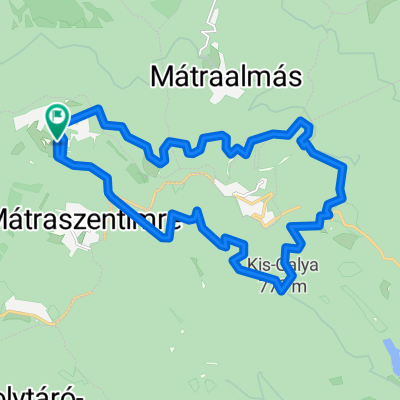
Zabar- (Cered-Rónafalu-Salgótarján)
A cycling route starting in Bátonyterenye, Nógrád megye, Hungary.
Overview
About this route
Bátonyterenye-Nemti-Nádújfalu-Pétervására-Istenmezeje-Zabar-Cered-Rónafalu-Zagyvaróna-Salgótarján-Bátonyterenye útvonalon majdnem 90 km-ben.
Az első 50 kicsit dimbes-dombos jól lehet tekerni,aztán jön a hegy.....,ha feljutsz akkor már csodálatos lefelé száguldani. Útközben készült képek a térképen!- -:--
- Duration
- 87.9 km
- Distance
- 534 m
- Ascent
- 534 m
- Descent
- ---
- Avg. speed
- ---
- Max. altitude

Route quality
Waytypes & surfaces along the route
Waytypes
Quiet road
13.2 km
(15 %)
Cycleway
7 km
(8 %)
Surfaces
Paved
64.2 km
(73 %)
Asphalt
64.2 km
(73 %)
Undefined
23.7 km
(27 %)
Route highlights
Points of interest along the route
\"")
Point of interest after 12 km
Nádújfalu előtt a Zagyva
\"")
Point of interest after 19.1 km
Megyehatár
\"")
Point of interest after 25.8 km
Pétervására...,egy parkban
\"")
Point of interest after 35.7 km
Istenmezeje-Noé szőlője
\"")
Point of interest after 39.8 km
Legek faluja-Zabar
\"")
Point of interest after 40.4 km
A falu temploma
\"")
Point of interest after 41.1 km
Ide jöttem..
\"")
Point of interest after 42.6 km
Cered felé elhagyom a falut
\"")
Point of interest after 50.1 km
Eddig nyugodt volt az út,jön a hegy
\"")
Point of interest after 50.5 km
Taposni kell :))
\"")
Point of interest after 52 km
Kicsi pihenő
\"")
Point of interest after 52.9 km
Bringáról...
\"")
Point of interest after 58.5 km
Felértem..,Rónabánya
\"")
Point of interest after 61.5 km
Valahol lefelé száguldok :))
\"")
Point of interest after 67.6 km
Óvóhely bejárata
\"")
Point of interest after 71.9 km
árnyékban...
\"")
Point of interest after 71.9 km
Narancs
\"")
Point of interest after 83.3 km
Kifeküdtem a hűvös fűre
Continue with Bikemap
Use, edit, or download this cycling route
You would like to ride Zabar- (Cered-Rónafalu-Salgótarján) or customize it for your own trip? Here is what you can do with this Bikemap route:
Free features
- Save this route as favorite or in collections
- Copy & plan your own version of this route
- Split it into stages to create a multi-day tour
- Sync your route with Garmin or Wahoo
Premium features
Free trial for 3 days, or one-time payment. More about Bikemap Premium.
- Navigate this route on iOS & Android
- Export a GPX / KML file of this route
- Create your custom printout (try it for free)
- Download this route for offline navigation
Discover more Premium features.
Get Bikemap PremiumFrom our community
Other popular routes starting in Bátonyterenye
 Campin ride-Szentkút
- Distance
- 17.8 km
- Ascent
- 142 m
- Descent
- 141 m
- Location
- Bátonyterenye, Nógrád megye, Hungary
 Kis edzés a Mátra északi lábánál I.
- Distance
- 54 km
- Ascent
- 532 m
- Descent
- 532 m
- Location
- Bátonyterenye, Nógrád megye, Hungary
 Kellemes 20 km
- Distance
- 20.2 km
- Ascent
- 310 m
- Descent
- 310 m
- Location
- Bátonyterenye, Nógrád megye, Hungary
 Sámsonháza
- Distance
- 37.9 km
- Ascent
- 207 m
- Descent
- 207 m
- Location
- Bátonyterenye, Nógrád megye, Hungary
 Lengyend
- Distance
- 15.3 km
- Ascent
- 224 m
- Descent
- 224 m
- Location
- Bátonyterenye, Nógrád megye, Hungary
 scele50
- Distance
- 46.3 km
- Ascent
- 1,332 m
- Descent
- 1,330 m
- Location
- Bátonyterenye, Nógrád megye, Hungary
 princz
- Distance
- 37.7 km
- Ascent
- 610 m
- Descent
- 608 m
- Location
- Bátonyterenye, Nógrád megye, Hungary
 Mátra kiskör
- Distance
- 27.9 km
- Ascent
- 473 m
- Descent
- 467 m
- Location
- Bátonyterenye, Nógrád megye, Hungary
Open it in the app