

RUTA MISAHUALLI-COCA SOLO SELVA
A cycling route starting in Tena, Napo, Ecuador.
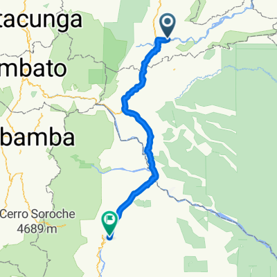
Overview
About this route
ADVENTURE
- -:--
- Duration
- 142.5 km
- Distance
- 516 m
- Ascent
- 659 m
- Descent
- ---
- Avg. speed
- ---
- Max. altitude

Continue with Bikemap
Use, edit, or download this cycling route
You would like to ride RUTA MISAHUALLI-COCA SOLO SELVA or customize it for your own trip? Here is what you can do with this Bikemap route:
Free features
- Save this route as favorite or in collections
- Copy & plan your own version of this route
- Split it into stages to create a multi-day tour
- Sync your route with Garmin or Wahoo
Premium features
Free trial for 3 days, or one-time payment. More about Bikemap Premium.
- Navigate this route on iOS & Android
- Export a GPX / KML file of this route
- Create your custom printout (try it for free)
- Download this route for offline navigation
Discover more Premium features.
Get Bikemap PremiumFrom our community
Other popular routes starting in Tena
 De Alto Pano.. a Tena
- Distance
- 12.6 km
- Ascent
- 24 m
- Descent
- 164 m
- Location
- Tena, Napo, Ecuador
 De Llanganates, Tena a Llanganates, Tena
- Distance
- 12.1 km
- Ascent
- 91 m
- Descent
- 88 m
- Location
- Tena, Napo, Ecuador
 tena macas
- Distance
- 199.2 km
- Ascent
- 1,440 m
- Descent
- 831 m
- Location
- Tena, Napo, Ecuador
 Planetrek Dia 10
- Distance
- 109.9 km
- Ascent
- 2,256 m
- Descent
- 840 m
- Location
- Tena, Napo, Ecuador
 2021-12-04 Tena-Rio Piatua 57km
- Distance
- 56.9 km
- Ascent
- 704 m
- Descent
- 525 m
- Location
- Tena, Napo, Ecuador
 Tena - Baños
- Distance
- 140.6 km
- Ascent
- 1,988 m
- Descent
- 686 m
- Location
- Tena, Napo, Ecuador
 Ruta a Tena
- Distance
- 8.4 km
- Ascent
- 180 m
- Descent
- 110 m
- Location
- Tena, Napo, Ecuador
 De Rio Shalcana, Tena a Rio Shalcana, Tena
- Distance
- 20 km
- Ascent
- 211 m
- Descent
- 208 m
- Location
- Tena, Napo, Ecuador
Open it in the app